This item has been sold, but you can enter your email address to be notified if another example becomes available.


|
||

|

|
|

|
Stock# 44239
Description
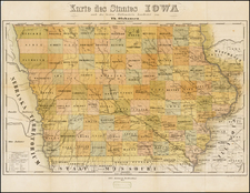
Rare early map of the surveyed portions of Iowa, from an early example of Morse's Cerographic Atlas of the United States.
Includes a number of counties, towns, rivers, etc. The map shows the settled portions of Iowa Territory, four years after it became a Territory in 1838.
Morse & Breese's North American Atlas was a landmark in American Cartography, being the first atlas to employ the cerographic printing process, which would revolutionize the map trade. The Morse family and this process are the subject of David Woodward's The All American Map. The maps were first printed in a series of inserts which appeared in the New York Post, and then later as a separate atlas.
![[ The Old Northwest Territory ] Il Paese De Selvaggi Outagamiani, Mascoutensi Illinesi E parte Delle VI Naxioni](https://storage.googleapis.com/raremaps/img/small/75927.jpg)