![[ Hawaii Discovered Before Cook? ] Iles Sandwich d'apres Cook / Groupe de la Mesa Tire de la Carte du Galion By Etienne Marchand](https://storage.googleapis.com/raremaps/img/small/101268.jpg)


|
||

|

|
|

|
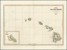
Finely detailed pair of maps of Hawaii, including a map based upon Cook's confirmed discovery of Hawaii and a second map memorializing the prospect that the island was actually discovered by the Spanish in 1568, from the first edition of Etienne Marchand's record of the second French Circumnavigation of the World.
The map at the left shows the route of Captain James Cook through the islands in 1777 and 1778, the first confirmed discovery of Hawaii.
The map on the right illustrates Marchand's discussion of the possibility of an earlier discovery of the island of Hawaii in 1568, by the Spanish explorer Alvaro de Mendana de Neira. "La Mesa," on Mendena's charts, may have been the island of Hawaii, so named because of the mesa-like appearance of Mauna Loa.
The Solide expedition was led by the French navigator Étienne Marchand (1755-1793). It was the second successful circumnavigation by the French, after Bougainville. It occurred from 1790 to 1792 but remains little known due to its mainly commercial aims, in the fur trade between the northwest American coast and China.
Spanish Contacts With Hawaii
Prior to Cook, there is some evidence to support the discovery of Hawaii by Spanish explorers in the mid-16th Century. The most compelling evidence supports the theory that Juan Gaetano, a Spanish navigator, visited Hawaii in 1555.
It is beyond question that Spanish ships were passing within a few hundred miles of Hawaii during this period, as they sailed between Latin America and the Far East. Spanish maps from the 1500s show islands that may well be Hawaii.
Interest in this topic reached its height in the early 1900s. In 1900, led by Professor William Alexander wrote: "There is little doubt that these islands were discovered by the Spanish navigator, Juan Gaetano, in the year 1555." Alexander was probably citing a document issued in February, 1865 from the Colonial Office at Madrid in Spain and addressed to the Governor of the Philippines, which provides in part
By all the documents that have been examined, it is demonstrated that the discovery [of Hawaii] dates from the year 1555 and that the discoverer was Juan Gaetano or Gaytan. The principal proof is an old manuscript chart, registered in these archives as anonymous, and in which the Sandwich Islands are laid down under that name, but which also contains a note declaring that he called them Islas de Mesa (Table Islands) There are besides other islands situated in the same latitude, but 10 degrees farther east and respectively named La Mesa, 'La Desgraciade, Olloa or Los Monges. The chart appears to be a copy of that called the chart of the Spanish Galleon, existing long before the time of Cook, and which is referred to by all the national and foreign authors that have been consulted Foreign authors say that It (the discovery) took place in 1542, in the expedition commanded by General Rui Lopez de Villalobo, while the Spanish chronicles denote 1555.
Two island groups, called Los Monges and Los Bolcanos, appear on a great many maps of the 16th, 17th and 18th centuries, and may represent the Hawaiian archipelago, according to Hawaii Roman Catholic historian Father Reginald Yzendoorn, writing in the 1920s:
The Los Bolcanos group, consisting of five islands, one of which is called Farfana (probably a misreading for La Tartana), appears for the first time in 1569 on Mercator's map: Nova et aucta orbis descriptio at between 22 and 26 degrees north latitude and about 176 degrees west longitude.
Los Monges are mapped for the first time by Abraham Ortelius on the map of America, made in 1587, and reproduced in the 1612 edition of his monumental atlas: Theatrum Orbis Terrarum. There they are at between 20 and 22 degrees north latitude and 159 and 162 degrees west longitude. Various cartographers during the two following centuries have maintained the Los Monges group on their maps, until Cook rediscovered and renamed them; whilst Los Bolcanos are mapped for the last time by J. A. Maginus in 1617.
Yzendoorn concludes: "A complete study of all these maps leaves no doubt as to the identity of these groups with the Hawaiian Islands."
![[Pearl Harbor] Pearl River and Lochs From The United States Government Plan of 1919...](https://storage.googleapis.com/raremaps/img/small/71708.jpg)