
This item has been sold, but you can enter your email address to be notified if another example becomes available.


|
||

|

|
|

|
Stock# 44159
Description
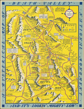
Lively pictorial map of Joshua Tree National Monument and environs, by Westways illustrator Lowell Butler.
The map provides a whimsical look at Joshua Tree, the Palm Springs, Indio, Salton Sea and Hemet Area.
There is no printing on the verso.
The map is quite scarce--we cannot locate another example. This is also one of the earliest maps of Joshua Tree National Monument. We find only a single Government map printed in 1936 which pre-dates this map.
![Central Valley Project -- California [Map and Views of California]](https://storage.googleapis.com/raremaps/img/small/91596.jpg)
![[ San Francisco Bay and Approaches ] Chart of the Farallones and Entrance to the Bay of San Francisco... 1850](https://storage.googleapis.com/raremaps/img/small/98405.jpg)
![[Early Landsat Photocomposite of California]](https://storage.googleapis.com/raremaps/img/small/90468.jpg)