|
||

|

|
|

|
Rare Early Geological Map of Southern California -- Illustrating It as a Petroleum Region.
This rare work focuses on the Geology of Southern California, including what would appear to be a very early study of fault lines and depressions.
The map is one of the earliest maps to focus on Southern California and one of the earliest to show it as a Petrolum producing region.
The map also notes gold, silver and copper mining in the San Gabriel and San Bernardino Mountains, including Lytle Creek. There is even a Marble deposit noted south of the Santa Ana River.
An Indian Village is noted on upper Santa Margarita River.
Below the map is a profile showing the entire coastline from Santa Barbara to the Mojave Desert.
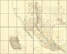
Guillemin-Tarayre's map is part of a rare set of scientific works published by the French government. The map illustrated a section which relates to geology and mining in California and Nevada. In 1864, as a result of a French military expedition to Mexico, the Commission Scientifique du Mexique was established. At the time, mining in California and Nevada were the focal point of a great deal of interest in Europe.