


|
||

|

|
|

|
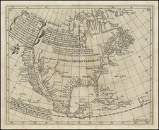
Early German Map of Virginia.
Rare German edition of Pierre Duval's map of the region centered on Virginia, the Chesapeake and the Carolinas, published by Johann Hoffman in his Geographiae Universalis, first issued in 1678.
The map is a close copy of the second and third states of Duval's map, which has been re-engraved by Sigismund Hipschmann. A second edition was published in 1681. The map includes an early depiction of the Chesapeake region, the mythical Lake May above Florida, Jamestown, Cape Henry, Secot, Pomeiok, an early reference to Manhattan and New Amsterdam and an inset of Bermuda.
Pierre Duval (1618-1683) was a French geographer, cartographer, and publisher who worked in Abbeville and Paris during the seventeenth century. He was born in the former city, in northeast France, before moving to Paris. Duval was the nephew of the famous cartographer Nicolas Sanson, from whom he learned the mapmaker's art and skills. Both men worked at the royal court, having followed the royal request for artists to relocate to Paris. In addition to numerous maps and atlases, Du Val's opus also includes geography texts. He held the title of geographe ordinaire du roi from 1650 and died in 1683, when his wife and daughters took over his business.
![(Florida-Georgia) Wie der Franzosen Oberster eine Seul / daran das Wapen dess Königes auss Franckreich / aussrichten lassen. [How the French commander had a seal made, on which the coat of arms of the King of France is displayed.]](https://storage.googleapis.com/raremaps/img/small/95828.jpg)
![[ The Marks of Sundry of the Chief Men of Virginia ] Aliquot Heroum Virginiae Notae.](https://storage.googleapis.com/raremaps/img/small/98859.jpg)
![(The First Letter From British Florida) [September 5, 1763, Autograph Letter, Signed, from Robert Campbell to John Campbell, 4th Earl of Loudoun, describing the British taking possession of Florida and the state of the settlement of Pensacola]](https://storage.googleapis.com/raremaps/img/small/86620.jpg)
![A New Map of Virginia [Chesapeake]](https://storage.googleapis.com/raremaps/img/small/43053.jpg)
