|
||

|

|
|

|
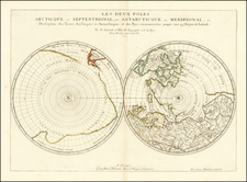
One of the earliest depictions of Cook's Discoveries in Australia and New Zealand.
Robert Sayer's double hemisphere map of the world is one of the first printed maps to show the discoveries of Captain James Cook in Australia and New Zealand.
Originally engraved for Spilsbury in the 1760s and intended as a puzzle map, the existence of this edition of the map, published circa 1772, was essentially unknown, until its recent discovery (in puzzle map format), but
As noted in the description to accompany the example owned by the State Library of New South Wales:
The map shows the routes of several notable explorers, namely Quiros (1605), Davis (1686), Bering (1741), Anson (1740-42), Wallis, and importantly, 'the track of Cook'. Cook's circumnavigation is plotted, with his discoveries along the East coast of Australia and exploration into the Southern Ocean. One of the earliest published maps showing Cook's first voyage . . . "
The State Library of NSW example can be found here: http://acms.sl.nsw.gov.au/album/albumView.aspx?itemID=936571&acmsid=0
No other surviving example of this state of the map is known to exist in sheet map form and the NLA puzzle map seems to be a singular surviving example in puzzle format, as the map was quickly revised by Sayer to show a corrected format for both Australia and New Zealand, in line with the printed maps which accompanied the official account of Cook's first voyage.
Robert Sayer (ca. 1724-1794) was a prominent London map publisher. Robert’s father was a lawyer, but his older brother married Mary Overton, the widow of prominent mapmaker Philip Overton and the proprietor of his shop after his death. Mary continued the business for roughly a year after her marriage and then, in early 1748, it passed to Robert. Robert became a freeman of the Stationers’ Company later that year; his first advertisement as an independent publisher was released in December.
Sayer benefited from Overton’s considerable stock, which included the plates of John Senex. In the 1750s, Sayer specialized in design books and topographical prints, as well as comic mezzotints. In 1753, he, along with John Roque, published a new edition of Thomas Read’s Small British Atlas, the first of several county atlases that Sayer would publish.
Sayer’s business continued to grow. In 1760 he moved further down Fleet Street to larger premises at 53 Fleet Street. In 1766, he acquired Thomas Jefferys’ stock when the latter went bankrupt. In 1774, he entered into a partnership with John Bennett, his former apprentice. The pair specialized in American atlases, based on the work of Jefferys. They also began publishing navigational charts in the 1780s and quickly became the largest supplier of British charts in the trade.
Bennett’s mental health declined, and the partnership ended in 1784. As Sayer aged, he relied on his employees Robert Laurie and James Whittle, who eventually succeeded him. He spent more and more time at his house in Richmond. In 1794, he died in Bath.
![Eastern Hemisphere [with] Western Hemisphere](https://storage.googleapis.com/raremaps/img/small/92642.jpg)