|
||

|

|
|

|
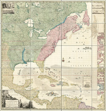
Manuscript map of the United States during the War of 1812, Including Several Famous Naval Battles involving the U.S.S. Constitution
The map is quite meticulously drawn, including fine annotations under several of the naval battle scenes providing an account of the battle in several instances, including:
- The Battle of Lake Erie, September 10, 1813
- US Sloop Wasp (Captain Jones) taking the HMS Frolick, October 18, 1812
- US Frigate Chesapeake (Captain Lawrence) engaged with HMS Shannon (Captain Broke) June 1, 1813
- US Frigate Constitution (Captain Hull) engaged with HMS Guerriere (Captain Dacres) August 10, 1812
- US Frigate Essex taking the HMS Allert, August 13, 1812
- US Frigate Constitution taking the HMS Java, Decmeber 29, 1812
- US Sloop of War Hornet (Captain Lawrence) taking the HMS Peacock, February 27, 1813
- US Frigate United States (Commodore Decatur) taking the HMS Macedonian, October 25, 1812.
Several of these scenes have been identified through the Shelton & Kensett map.
Shelton & Kensett's Map
Shelton & Kensett were among America's foremost engravers of the early 19th Century and their work is highly prized among collectors.
This important pair of American engravers produced one of the very few separately issued printed maps of the War of 1812, to depict the entire theater of the war, and the only map to includes such a detailed focus on the naval battles fought by the American and British Navies.
There are 3 editions of the map, with varying numbers of vignettes. While at first appearance, it would make sense that the vignettes were added with each new edition, we note that the editions with 7 and 10 vignettes appear very similar in all other respects, whereas the edition with 9 vigettes has different spellings of Cape Fear in the vignette above the title eagle and that there are many other subtle differences throughout the map, leading us to believe that the 9 vignette edition of the map is in fact an entirely different plate, likely issued at a later date. The 9 vignette edition (copyrighted on November 8th, 1813), whereas the 7 and 10 vignette editions are dated July 6th, 1813.
The 9 Vignette map can be seen here: /gallery/detail/23798
The 7 vignette edition can be seen here: www.davidrumsey.com/luna/servlet/detail/RUMSEY~8~1~222569~5505625:An-Improved-Map-of-the-United-State
The 10 vignette edition can be seen here: /gallery/detail/30877

![The Travellers Guide or Map of The Roads, Canals & Rail Roads of the United States, With the distances from Place to Place By H.S. Tanner 1845 [with] The American Traveller, or Tourists' and Emigrants' Guide Through The United States . . . .](https://storage.googleapis.com/raremaps/img/small/99038.jpg)
![[ US-Mexico Border Survey: General Order From the President of the United States Directing William H. Emory to lead the US-Mexico Boundary Survey ]](https://storage.googleapis.com/raremaps/img/small/101837.jpg)