


|
||

|

|
|

|
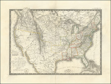
Rare (unrecorded?) Variant of the Purcell / Harrison Map of the Southeast, including the New State of Franklin.
Fine example of Purcell's map of the Southern States (and Midwest), which includes an early reference to the New State of Franklin in the center part of North Carolina.
Purcel's map first appeared in Jeddidiah Morse's American Georgraphy, and in some copies of the August 1788 edition of the American Magazine. Later examples were issued by Stockdale in London, engraved by W. Harrison. This is a rare separately issued example, as explained below.
The map is one of the few maps to record the short-lived state of "Franklinia." In the latter part of the 18th Century, the settlers in Western North Carolina and Eastern Tennessee decided that because of poor representation in State Government, they needed to form a state of their own. A government was formed and initial organizational meetings conducted, but the breakaway state was quickly quelled by the North Carolina authorities, although not before the State of Franklinia began appearing on a number of English maps during the period. Ben Franklin himself responded that while he was honored by the decision to name a state after him, he was not able to relocate.
Shows the boundaries between the United States and Spanish Dominions, lines delimiting Indian Nations, Towns, Roads, Indian Villages and host of other early details, including counties, Indian Trade paths, the Seven Ranges, Ekanfanoka Swamp (Okenfenokee), and Port Vincient (Vincennes), The Ohio Company, New Jersey Company and Illinois Company Lands are shown, as are the Donation Lands of the Commonwealth of Virginia.
The Illinois, Indiana & New Jersey Company land areas appear, as do Army Land, Ohio Company, along with numerous counties in Virginia. Notes regarding Col. Syms Land, the donation grants and Gen. Clark's Grant are also shown. The Spanish Dominions and Louisiana appear east of the Mississippi River, and the region north of Virginia is called the New States, although predating the deliniation of Ohio, Indiana and Illinois. Many other interesting details.
Separately Issued Variant
The present example includes to the right of the Stockdale imprint, the letters " A.d. " The map was acquired as a pair, with the accompanying northern sheet, which bears the note at the left " Se Vend Chez F. Mony a Geneve ." Both have wide margins and single vertical fold, suggesting they were bound into a composite atlas. Taken together, it would appear that Purcell's map was being offered for sale as a separate map in Geneva. The lettering also suggests that it was likely stamped onto the map by Monty in Geneva when the sheet arrived in Geneva, and was not added by Stockdale.
A link to the other map is here: /gallery/detail/44064
We know of no other surviving example with these imprints.

![[New Castle, Delaware]. Sandhocken (Fort)](https://storage.googleapis.com/raremaps/img/small/79459.jpg)
![[ Atlas of The United States ] Karte von Amerika](https://storage.googleapis.com/raremaps/img/small/84353mp2.jpg)