|
||

|

|
|

|
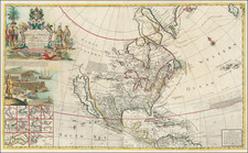
Interesting map of North America, in the interim period between the French & Indian War and the American Revolution.
This map is perhaps most notable for the inclusion of Feu-sang, reflecting the belief that Chinese mariners may have reached America, the location of the mythical colony of Fou-sang. According to some historians such as Charles Godfrey Leland and Joseph de Guignes ( Le Fou-Sang des Chinois est-il l'Amérique Mémoires de l'Académie des Inscriptions et Belles Lettres, tome 28, Paris, 1761), the distances given by Hui Shen (20,000 Chinese li) would locate Fou-sang on the west coast of the American continent, near British Columbia.
This is also one of the few maps to name the "Sea of Anadir."
The map shows the mythical River of the West, tentatively running from the Rocky Mountains to Puget Sound, searching hopefully for a short portage from the headwaters of several major rivers flowing to the south and east.