


|
||

|

|
|

|
Unrecorded Early Mapping of New Zealand.
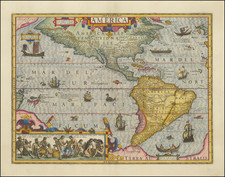
Previously unrecorded second state of J.B.B. D'Anville's map of the Western Hemisphere, incorporating a wholly unique depiction of New Zealand, quite likely using the earliest obtainable reports of Cook's contacts with New Zealand and information from contemporary French expeditions to New Zealand by De Surville and Du Fresne.
J.B.B. D'Anville first issued this large format map of the Western Hemisphere as part of a pair of hemispheric maps issued in 1761. The map depicted the classical eastern coastline of New Zealand, based upon the discoveries of Abel Tasman in December 1642. Until the discovery of this map, it was believed that the D'Anville western hemisphere map remained unchanged until circa 1774, when it was updated to incorporate the discoveries of James Cook in New Zealand.
- 1761 edition: http://cartweb.geography.ua.edu/lizardtech/iserv/calcrgn?cat=World&item=Western%20Hemisphere/Westhemi1761b.sid&wid=500&hei=400&props=item%28Name,Description%29,cat%28Name,Description%29&style=simple/view-dhtml.xsl
- circa 1774 edition: /gallery/detail/31597
The present map reflects a short-lived period, prior to the full dissemination of Cook's mapping of New Zealand, which may reflect information known to D'Anville from French sources following the voyages of Surville and Du Fresne, in addition to some early information (unofficial) Cook information.
The present map exhibits seveal very curious features, suggesting a very early attempt to re-work the cartography of New Zealand, without the aid of Cook's maps.
- The entire "Tasman" Coastline has been moved about 2.5 degrees east. In state 3, the whole would again be moved another 2 degrees to the east.
- The Tasman's small coastal mountain near Cape Boreel has been moved into the center of the newly created North Island
- Tasman's Rade (Bay) has been retained, but the word Detroit (Strait) has been inserted.
- Two distinct islands have been plotted, however most of the coastline of the south island is drawn in a style indicating that it is conjectural in nature. In state 3, D'Anville would name these islands Tavai-Poenamoo for the South Island and Mahai-Nomai for the North Island.
- In the south Island, only C. du Sud (South Cape) is expressed with certainty.
As noted above, this is the only known example of this state of D'Anville's map, which he apparently revised very shortly thereafter, utilizng better information, as details of Cook's expedition became better known.
The present mapping of New Zealand shows several curious features.
- The improved Northernmost coastline, to the east of C. du Nord, extends more than 1 full degree, and may reflect information derived from the charts of the same coastline by Surville and Du Fresne, in addition to early reports from Cook. This feature extends beyond Tasman's information, but curiously does not continue as far as the full extent of Cook's coverage.
- D'Anville was without anything which he considered reliable source for the northeastern coastline of of the north Island and the eastern coastline of the South Island.
- D'Anville was without the final coordinates brought back by Cook for the island, but had some preliminary information sufficient to pursuade him to move the island north about 2.5 degrees.
- D'Anville had sufficient information to relocated the unnamed Tasman coastal mountain (Mt. Taranaki / Egmont) well inland of its original location, to a place which does not correspond with either Cook, Tasman or du Fresne's placement.
Jean-Francois-Marie De Surville
In 1767, de Surville set sail in his ship, the St Jean Baptiste, to India to trade between the French settlements in India and China. In 1768, while in India, he heard rumours that the British had discovered a fabulously wealthy island in the South Pacific and decided to try to find this island. De Surville reached New Zealand on December 12,1769. He and Cook (who reached New Zealand in October 1769) passed each other in the night without noticing. The chaplain, Father Paul-Antoine Léonard de Villefeix, conducted the first Christian services in New Zealand on Christmas Eve and Christmas Day 1769, in Doubtless Bay.
The St Jean Baptiste continued east across the Pacific and suffered further loss of crew through scurvy. De Surville drowned in heavy seas off the Peru coast, in April 1770 while seeking help for his dying crew. His ship did not return to France until August 1773.
During his time in New Zealand, De Surville prepared two manuscript charts, which survive in the Bibliotheque National de Paris:
- Coastline between Cape Maria van Diemen and North Cape: https://doubtlesswine.files.wordpress.com/2010/03/de-surville-far-north.jpg
- Doubtless Bay (which de Surville named Lauriston Bay). https://doubtlesswine.files.wordpress.com/2010/03/de-surville-doubtless-bay.jpg
Marc-Joseph Marion du Fresne
Following the demise of the French East India Company in 1769, Du Fresne was able to convince Pierre Poivre, the civil administrator of Isle de France (Mauritius) and Ile Bourbon (Reunion Island), to equip him with two ships and send him on an expedition to the South Pacific. Du Fresne's fellow explorer Louis Antoine de Bougainville had recently returned from the Pacific with a Tahitian native, Ahutoru. Du Fresne was engaged to return Ahutoru to his homeland, and then to explore the south Pacific for Terra Australis Incognita. For these purposes Du Fresne was given two ships, the Mascarin and the Marquis de Castries. Shortly after setting sail, Ahutoru died of smallpox.
Du Fresne reached New Zealand on March 25, 1772, making landfall at Cape Egmont, first sighting Mount Taranaki on his approach from the west. Over the next month, his expedition explored the islands, repaired their two ships and treated their scurvy, first anchoring at Spirits Bay, and later in the Bay of Islands. Apparently their relations with the Māori were peaceful at first. They could communicate thanks to their Tahitian vocabulary learned from Ahutoru, and the Māori even held a ceremony for them. Later it appears that Maori decided to attack the French to obtain their guns, tools and supplies. Du Fresne and 26 of his men were killed and eaten.
During the time in New Zealand, Du Fresne created three manuscript charts which still survive at the BnF.
- Plan des terres de la Nouvelle Zelande parcourues par la flute de Roy Le Mascarin (including vu la pique mascarin)
- Partie du Nord de La Nouvelle Zelande (including an illustration called "Pic Marion", in the same location ad Mt. Egmont)
- Plan du Port Marion
While there is no evidence that D'Anville had seen the manuscript charts and unpublished accounts of the two French expeditions, the present map offers some fascinating possibilities.
Abel Tasman
The first visit to New Zealand had occurred more than 100 years earlier, when Abel Janszoon Tasman (1603 - 1659), a Dutch explorer and merchant in the employ of the Dutch East India Company (VOC) first arrived to New Zealand from Tasmania on December 13, 1642, spending time at the entrance to Cook's Strait, but unable to enter because of adverse winds. They proceeded northward, passing Mount Egmont / Taranaki, which was shrouded in fog. The expedition continued along the coastline northward until it lost contact with land on January 4, 1643.
Tasman's expedition resulted in two surviving manuscript charts of parts of the west coast of New Zealand, as well as profile views. Both the charts and one of the profile views depicts a mountain which would become Mount Egmont / Mount Taranaki.
One of the earliest appearances of the Tasman contact with New Zealand appears on the fourth state of the Hondius / Jansson untitled chart of the south polar regions. Toward the center of the coastline shown on the Jansson map, there is an indication of a small mountain adjacent to C. Pieter Boreel (which would be re-named Cape Egmont).
- Abel Tasman's Chart: http://nzetc.victoria.ac.nz/etexts/BeaDisc/BeaDiscP002a.jpg
- rans Visscher's Chart: http://www.teara.govt.nz/en/map/10759/map-of-nova-zeelandia
Conclusion:
Based upon the foregoing, it would seem without question that D'Anville was attempting to reconcile new cartographic information for which he had only an incomplete and perhaps conflicting picture.
The location of the Strait between the two islands suggests that either D'Anville also had some very early information from the Cook expedition or even perhaps that one of the two French expeditions brought back information available to D'Anville. Certainly, D'Anville would have had access to the best available French sources.
D'Anville was a highly disciplined mapmaker, who would, in 1775, would become the Geographer to the King of France and to the French Academy of Sciences, positions for which he prevailed over the likes of Gilles and Didier Robert de Vaugondy and Jean-Nicholas Buache de Neuville, each of whom was much younger and in the prime of their productive careers. His stature in official circles and access to the most recent French expeditionary material would have been assured.
As such, his decision to radically revise the depiction of New Zealand, prior to the full dissemination of Cook's reporting would not have been without good cause and sufficient information upon which to construct this curious model.
Jean-Baptiste Bourguignon d’Anville (1697-1782) was one of the foremost French geographers of the eighteenth century. He carried out rigorous research in order to create his maps, which greatly developed the technical proficiency of mapmaking during his lifetime. His style was also simpler and less ornate than that of many of his predecessors. It was widely adopted by his contemporaries and successors.
The son of a tailor, d’Anville showed cartographic prowess from a young age; his first map, of Ancient Greece, was published when he was only fifteen years old. By twenty-two, he was appointed as one of the King’s géographes ordinaire de roi. He tutored the young Louis XV while in the service to the Crown. However, royal appointment did not pay all the bills, so d’Anville also did some work for the Portuguese Crown from 1724. For example, he helped to fill out Dom João V’s library with geographical works and made maps showing Portugal’s African colonies.
D’Anville disapproved of merely copying features from other maps, preferring instead to return to the texts upon which those maps were based to make his own depictions. This led him to embrace blank spaces for unknown areas and to reject names which were not supported by other sources. He also amassed a large personal map library and created a network of sources that included Jesuits in China and savants in Brazil. D’Anville’s historical approach to cartography resulted in magnificently detailed, yet modern and academic, maps. For example, his 1743 map of Italy improved upon all previous maps and included a memoir laying out his research and innovations. The geographer also specialized in ancient historical geography.
In 1773, d’Anville was named premier géographe de roi. In 1780, he ceded his considerable library to the Ministry of Foreign Affairs to be used for as a reference library for diplomats. D’Anville is best known for several maps, including his map of China, first published in 1735, and then included with Du Halde’s history of that country (the Hague, 1737). His map of Africa (1749) was used well into the nineteenth century.
![[English Edition!] Maris Pacifici quod vulgo Mar del Zud](https://storage.googleapis.com/raremaps/img/small/71000.jpg)