|
||

|

|
|

|
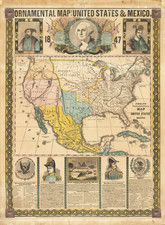
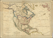
Marvelous highly detailed map of North America, during the earliest period of the "Oregon Question."
The present map highlights the area in question during the Oregon Question, separately identifying the region as "Western Territory."
The British-American conflict over this region dates to the era of Lewis & Clark, when President Thomas Jefferson first put play his vision of American Manifest Destiny--a country extending from the Atlantic to the Pacific. While competing British Interests in the region had been the subject of potential challenges from Russia, Spain and France, the American purchase of Louisiana Territory gave greater immediacy to th issues.
Prior to 1818, there had been some limited intrigue in the region. The American Pacific Fur Company had posed some limited disruption to the historic control of the region by the British and the HMS Raccoon had been ordered to capture Fort Astoria, but generally there was very little to fight about in the region.
With the Treaty of 1818, the British and American diplomats first attempted to establish a boundary west of the Rocky Mountains, but instead of agreeing upon the 49th Parallel, as had been done to the east, the parties agreed to a 10 year "joint occupation." In 1824, the parties again started to discuss the boundary, but without success. Instead, an agreement was reached that either party would have 1 year to place the question of the boundary into a formal proceeding.
The present map was published during the first year of the "1 year agreement."
The map also includes a massive Missouri Territory extending to the Rocky Mountains, Russian Territory and many other early features.
The Rio Sacramento is flowing from Lake Timpanagos (Salt Lake) to San Francisco,with a smaller Rio San Felipe extending from L. Sale to Monterey.
The Rio de los Martires reaches from north of San Diego Bay to Southern Utah. The Colorado River headwaters are well north of the true source. Most of the California Missions are shown.
![[ Chinese Voyages To America, etc. ] Memoires De Litterature, Tires Des Registres De L'Academie Royale Des Inscriptions et Belles-Lettres Depuis l' annee M. DCC. XVIII. julques & compris l'annee M. DCC. XXV Tome Quarante-Neuvieme](https://storage.googleapis.com/raremaps/img/small/101296.jpg)