This item has been sold, but you can enter your email address to be notified if another example becomes available.


|
||

|

|
|

|
Stock# 43595
Description
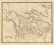
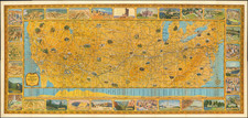
Fine map of the British Colonies in North America, which appeared in The North American Gazetteer.
This large copperplate map shows the British view of their colonies at the time of the American Revolution.
The mythical islands in Lake Superior are a hold-over from earlier French cartographers, who made them up to honor their government patrons.
The large triangular table at the lower right gives distances between American cities.
Little is known about John Lodge beyond that he was a London engraver of the middle and late eighteenth century. His maps appeared in many popular periodicals as well as in books, and before his death in 1796 he produced a general atlas of Great Britain.
Reference
McCorkle, B.B. (New England) 776.15; Sellers & Van Ee #160.