


|
||

|

|
|

|
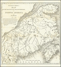
Highly detailed map of the northern part of the United States, which appeared in Voyage Dans la Haute Pennsylvania by Michel Guillaume de Crevecoeur.
The map extends from the northern reaches of Chesapeake Bay to Maine and eastward to show most of Lake Erie.
Among the most noteworthy features of the map is its meticulous detail in the area between the Mohawk River and Susquehannah River in New York, detailing the township names given in the Military Tract of Central New York, also called the New Military Tract, which consisted of nearly two million acres of bounty land set aside to compensate New York's soldiers after their participation in the Revolutionary War.
There are a number of place names and details including the road system in the nascent nation; and also information on Indian tribes and villages.
Crevecoeur was a French immigrant to the United States who gain fame describing the emerging American national character in his Letters of an American Farmer, first published in 1782.
New Military Tract
The United States Congress had already guaranteed each soldier at least 100 acres at the end of the war (depending on rank), but by 1781, New York had enlisted only about half of the quota set by the U.S. Congress and needed a stronger incentive. The state legislature authorized an additional 500 acres per soldier, using land from 25 Military Tract Townships to be established in central New York State. Each of the townships was to comprise 100 lots of 600 acres. Three more such townships were later added to accommodate additional claims at the end of the war.
The 28 Townships were given classical Greek and Roman names, along with the names of English authors. The tract covered the present counties of Cayuga, Cortland, Onondaga, and Seneca, and parts of Oswego, Tompkins, Schuyler and Wayne. The names themselves have been attributed to Robert Harpur, a clerk in the office of New York's Surveyor General, Simeon De Witt. Harpur apparently had an interest in classical literature.
The portion of the Military Tract north of Seneca Lake (i.e. townships of Galen and Junius) was divided by the New Preemption Line from land to its west assigned by the Treaty of Hartford of 1786 to Massachusetts. The tract immediately to the west became the Phelps and Gorham Purchase. The west limit of most of the tract was Seneca Lake.
Two Indian reservations were included in the Tract, for the Onondaga and Cayuga. All of the Cayuga and most of the Onondaga (including the City of Syracuse) were taken a few years later by New York State by treaties whose legality has been repeatedly challenged, since following the Trade and Intercourse Act of 1790 only the United States could conclude treaties with Indians.
![[ English Plantations in North America ] A New Map of the most Considerable Plantations of the English In America Dedicated to His Highness William Duke of Glocester.](https://storage.googleapis.com/raremaps/img/small/98233.jpg)


![[ Pictish Man Holding Severed Head ] Picti icon](https://storage.googleapis.com/raremaps/img/small/99837.jpg)
![[The First Maps Printed Color] Cartes en Couleur des Lieux Sujets aux tremblements de Terre Dans toutes les parties du Monde Selon le Sisteme de l’impulsion Solaire](https://storage.googleapis.com/raremaps/img/small/52293op.jpg)