|
||

|

|
|

|
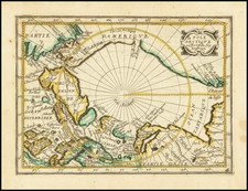
Fine chart of the South Pole, showing the extent of explorations and surveys in the South Polar Regions through 1927.
Fine admiralty chart of the South Polar regions published June 10, 1927 under the supervision of Rear Admiral H.P. Douglas, CMG, Hydrographer. The chart shows the most advanced obtainable information, including the routes that both Scott and Amundsen travelled to reach the pole as well as other "furthest south" points attained by vessels at sea.
The map also includes geographical features of mapped regions (Graham Land, Coats Land, King George V Land, Queen Mary Land, etc) as well as the vast expanses of "blank" areas yet to be explored.
The present example includes extensive pencil annoations and a manuscript compass, with annotations relating to several important expeditions, including primarily notes concerning Shackleton's Third Expedition to the South Pole, noting
- Sinking of the Endurance on November 21, 1915
- Shackleton's "Endurance" January to November 1915.
- Tottan's Landing
- Theron's Landing
- The Polar Route of 1957 (Scott Base?)
- Several "Forward Bases"
- 1st Bae Hillary's Party
Drawn in 1927, the map illustrates the information derived from a number of early 20th Century expeditions, ending with the Shackleton-Rowett Expedtion and the Britsih Graham Land Expedition.
The chart is quite scarce, this being the first example we have ever seen.
The British Admiralty has produced nautical charts since 1795 under the auspices of the United Kingdom Hydrographic Office (HO). Its main task was to provide the Royal Navy with navigational products and service, but since 1821 it has also sold charts to the public.
In 1795, King George III appointed Alexander Dalrymple, a pedantic geographer, to consolidate, catalogue, and improve the Royal Navy’s charts. He produced the first chart as the Hydrographer to the Admiralty in 1802. Dalrymple, known for his sticky personality, served until his death in 1808, when he was succeeded by Captain Thomas Hurd. The HO has been run by naval officers ever since.
Hurd professionalized the office and increased its efficiency. He was succeeded by the Arctic explorer Captain William Parry in 1823. By 1825, the HO was offering over seven hundred charts and views for sale. Under Parry, the HO also began to participate in exploratory expeditions. The first was a joint French-Spanish-British trip to the South Atlantic, a voyage organized in part by the Royal Society of London.
In 1829, Rear-Admiral Sir Francis Beaufort was appointed Hydrographer Royal. Under his management, the HO introduced the wind force scale named for him, as well as began issuing official tide tables (1833). It was under Beaufort that HMS Beagle completed several surveying missions, including its most famous voyage commanded by Captain FitzRoy with Charles Darwin onboard. When Beaufort retired in 1855, the HO had nearly two thousand charts in its catalog.
Later in the nineteenth century, the HO supported the Challenger expedition, which is credited with helping to found the discipline of oceanography. The HO participated in the International Meridian Conference which decided on the Greenwich Meridian as the Prime Meridian. Regulation and standardization of oceanic and navigational measures continued into the twentieth century, with the HO participating at the first International Hydrographic Organization meeting in 1921.
During World War II, the HO chart making facility moved to Taunton, the first purpose-built building it ever inhabited. In 1953, the first purpose-built survey ship went to sea, the HMS Vidal. Today, there is an entire class of survey vessels that make up the Royal Navy’s Hydrographic Squadron. The HO began to computerize their charts in the late 1960s and early 1970s. In 1968, the compilation staff also came to Taunton, and the HO continues to work from there today.
![[ Antarctica ] [Signed and Annotated by Robert A. English, Commanding Officer of the Bear of Oakland] Reconnaissance Map. King Edward VII Land. The Northern Part of Marie Byrd Land. Based mainly on air photographs taken by Capt. A.C. McKinley on the Byrd Antarctic Expedition 1928-1930 . . .](https://storage.googleapis.com/raremaps/img/small/89439.jpg)