|
||

|

|
|

|
The Final Example of the Most Influential Map of the Middle British Colonies Published in the 18th Century
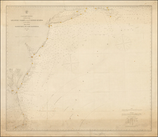
Fine old color example of the Laurie & Whittle edition of Lewis Evans' landmark map of the Middle British, published from the Surveys of Evans, Thomas Walker and Christopher Gist, 1750-51.
Evan's map, along with the maps of North America by Henry Popple and John Mitchell, are widely considered to be the most important and influential maps of the British Colonies published in the 18th Century. The map was originally sent to the London Board of Trade in 1751 and used by General Braddock during the French & Indian War. The map was later published by Benjamin Franklin in Philadelphia, in 1755. Henry Stevens documents 18 states of the map, of which this example is a so-called pirated edition by Laurie & Whittle.
The map was the first to show oil in Pennsylvania, first to show coal in Ohio, and the first to accurately map the trans-Appalachian and Ohio River region. Evans map is a towering landmark in the history of American Cartography and the subject of numerous scholarly texts.
This is a fine full original example of this important map, updated to reflect post Revolutionary war details. Large inset of the region bounded by Lake Superior, the Mississippi and Alleghany Rivers.
James Whittle (1757-1818) was a British engraver and map printer. Whittle was employed by Robert Sayer (ca. 1725-1794). Together with Robert Laurie (1755?-1836), he took on Sayer’s business when the older man died in 1794. The two traded together as Laurie & Whittle until 1812, when Laurie retired. They had specialized in sea charts and maritime atlases. Whittle then partnered with Laurie’s son, Richard Holmes Laurie, until he died in 1818.
Robert Laurie (1755?-1836) was a British engraver and printseller who specialized in engraving portraits and in publishing maritime charts. His family originated in Dumfriesshire. As a young man he came to London and was apprenticed to Robert Sayer (ca. 1724-1794) in 1770. He received several awards in the 1770s for his mezzotint engraving and printing. He worked for Sayer as apprentice, assistant, and later partner.
In 1794, when Sayer died, Laurie took on his business alongside James Whittle, his fellow Sayer employee. Laurie managed the business and ceased almost all engraving. Instead, he oversaw the prodigious output of printed materials, especially sea charts and maritime atlases. He retired in 1812.
Laurie’s son, Richard Holmes Laurie, took over his part of the business and continued in business as Whittle & Laurie, rather than the previous Laurie & Whittle. Whittle died in 1818, leaving Richard as the sold proprietor of the business. Robert died in 1836 in Hertfordshire.
![[ Southern Railroads ] Railroad Map of the Southern States Shewing the Southern & Southwestern Railway Connections With Philadelphia. 1862 . . . Prepared by Thomas Kimber Jr., Chairman of the Committee on Inland Transportation of the Board of Trade of Philadelphia](https://storage.googleapis.com/raremaps/img/small/103211.jpg)