|
||

|

|
|

|
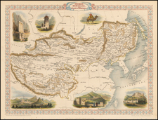
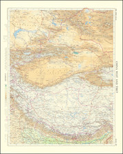
Southeast Asia in Focus
Striking example of De Wit's map of Southeast Asia, engraved by Joannes Lhulier in 1662.
The map shows southern Asia from southeastern Persia to northwestern Australia. The focus, however, is on India and Maritime Southeast Asia, where European joint-stock companies were busy establishing entrêpots, forging trade relationships, and forming political alliances.
The many islands of the area are clearly depicted, with ports shown prominently. Mountainous interiors are also emphasized, as are lakes like the mythical Lake Chiamay (see below).
The East Indies and the Philippines are well formed for the time. To the east of Celebes are the Moluccas, or the Spice Islands, access to and control of which were highly sought after by Europeans eager for nutmeg, cloves, and mace.
One eastern island that is unfinished is called, “Terra d’os Papous a Jacobo le Maire dicta Nova Guinea.” The western part of what is today Papua New Guinea, this large island was first encountered by Europeans when circumnavigators led by Willem Schouten (and Jacques LeMaire, who died on the final leg of the journey back to Holland) cruised along the northern coast in 1616.
In the southeast, a large strait seems to separate New Holland (Australia) from Java and Timor. This would a bold cartographic statement, as many contemporary mapmakers opted instead to suggest that Carpentaria, part of New Holland, and the islands of Southeast Asia were connected or separated by only the narrowest of passages. The Spanish knew there to be a strait between the lands, as Torres, a Spanish captain, had sailed through it in the early seventeenth century. However, the Spanish suppressed this information; it was only uncovered by Alexander Dalrymple following the British seizure of Spanish Manila in 1762. An examination of De Wit’s world maps, reveals this supposed strait to be something of an illusion. The eastern neat line cuts off Carpentaria, which elsewhere De Wit shows as nearly touching Papua New Guinea.
The map is comparatively unadorned save for the title cartouche in the upper right corner. It shows four men with hairstyles and clothing that show European perceptions (and stereotypes) of Asians in the early modern period.
De Wit’s map was influential. It served as the prototype for other maps of Southeast Asia, such as the one issued by Francis Lamb in the 1676 edition of Speed's atlas.
The Dutch and English East India Companies and the Indian Ocean World in the seventeenth century
Sixty years before this map was published, the Dutch (1602) and English (1600) East India Companies were founded in order to trade directly with the Indian subcontinent. They followed Portuguese traders who had set up trading forts on the subcontinent. They also relayed trade from the lucrative Spice Islands in southwest Asia. Both companies operated a monopoly over trade and gained immense power.
By 1700, the Dutch and English were joined by the French and Danish East India Companies, but the English were by far the strongest presence in Asia at that time. Eventually, during the century after the publication of this map, the lines between commercial and political dominance became increasingly blurred. The English East India Company's control of the seas, greater resources, and more advanced military training and technology led it to become attractive to a portion of the Indian elite. These factors were crucial in allowing the Company to gain control over the Bengal region by 1765 and to sideline other European countries. India later became a British colony.
The Maldives, to the east of India, had long been coveted as a valuable port and they held importance due to their central location within the Indian Ocean, half way between Africa and the Straits of Malacca. The Portuguese were the first Europeans to come, in 1558, but they were resisted by the mostly Islamic population. The Dutch came next, in the mid-seventeenth century, but they only ensured their access to ports and watering; they did not involve themselves in local affairs. Long after this map was published, in 1796, the British took the Maldives from the Dutch and it became a protectorate in 1887.
The colonial fate of the Maldives was tied to that of Ceylon, which is now known as Sri Lanka. Like the Maldives, the Portuguese were the first Europeans to arrive, in 1505. They built a fort and extended their rule over the island, despite intense Indigenous resistance and the survival of the independent Kingdom of Kandy. In 1638, the Dutch East India Company (VOC) signed a treaty with King Rajasinghe II to eject the Portuguese. The Dutch controlled Columbo by 1656 but, instead of leaving as promised, they stayed and they were the main controlling force on the island when this map was published.
Again like the Maldives, Britain occupied the island in 1796 as part of the Napoleonic Wars. The Kingdom of Kandy fought off a British invasion in 1803, but the British, under the auspices of the East India Company, remained a powerful presence on the island. Kandy was defeated in 1815, leaving the entire island in British hands.
Additionally, the map shows the Andaman Islands, or the Andemaons, as they are written here. Unlike the Maldives or Sri Lanka, the Andamans were not a valuable trade center. Indeed, they were and remain one of the only places on Earth that have had little to no contact with the developed world. The Nicobar Islands, to the south, were colonized by the Danish East India Company in 1755, long after this map was published. The British later set up outposts on the Andaman Islands, but the local peoples frequently attacked shipwrecked survivors and lone Europeans, gaining a fearsome reputation in the process.
The political map of South and Southeast Asia: the Mughal Empire, Arakan, and Tonkin
The map shows several political entities which are no longer so familiar to the modern eye, namely the Mughal Empire, Arakan (here Aracam), and Tonkin (here Tonquin). The Mughal Empire began when Babur (r. 1526-1530), originally from Central Asia, established himself in Kabul, Afghanistan and marched south into India via the Khyber Pass. His descendants consolidated power and fought off rivals. Particularly under the rule of Akbar (r. 1556-1605), the Mughal Empire developed an imperial structure characterized by tolerance of religious differences and a competent administrative elite.
Later in the seventeenth century, the Mughal Empire developed not only as a center of arts and culture—the Taj Mahal was built during this time—but as a political and economic power house. By 1707, under the controversial ruler Aurangzeb (r. 1658-1707), the Mughal Empire reached its largest extent, encompassing much of the Indian subcontinent. A decade later, however, the empire entered into decline. Many of the areas that had been added by Aurangzeb were in open revolt and the dynastic line was in chaos. In 1719, four separate emperors ruled. The Mughal Empire began to lose land and influence, particularly in the face of Maratha opposition and the arrival of the British East India Company.
The kingdom of Arakan, here Aracan, was an Indianized kingdom nestled between the Indian subcontinent, the Bay of Bengal, and what was historically known as Burma. At a significant crossroads in trade routes to India, China, and Southeast Asia, Arakan was diverse religiously and ethnically. Islam came to the region in the eighth century. The Rakhine people migrated to the area around the ninth century; today, the area is Rakhine State in Myanmar. The area was also a site of conflict, with the Burmese and Bengal Sultanate just some of those who sought to control the strategic and economically-important region. Arakan was able to survive and had a formidable navy by the seventeenth century.
However, the Dutch and the Portuguese were also drawn to the trade center. The Dutch arrived in 1623; thirty years later, they completed a treaty that gave the Dutch East India Company duty-free trade rights. However, in 1665 the Mughals smashed the Arakan fleet, forcing the area into decline.
Tonkin (also Tongkin, Tonquin, Tongking) refers to the northern part of what is today Vietnam. It means “eastern capital,” in reference to Hanoi. In the first millennium CE, the area for a time was under the control of China. After 938, however, it was independent and ruled by the Ngô, Đinh, Early Lê, Lý, Trần, and Hồ dynasties. Disputes with China continued, with Lê Lợi as a notable leader who fought the Ming dynasty and established himself in Hanoi in the mid-fifteenth century. By the seventeenth century, Westerners were frequent visitors to the area. They traded with the Trinh lords who were then in power. The French took the area as a protectorate from 1884 to 1945.
Lake Chiamay first appeared on a map in 1554 when it was included on the terza tavola in the second edition of volume one of Ramusio’s Delle navigationi et viaggi. Drawn by Giacomo Gastaldi, this map of South and Southeast Asia shows a massive lake from which four rivers flow; these are commonly interpreted as the Chao Phraya, Salween, Irrawaddy, and a branch of the Brahmaputra, but also sometimes include other rivers.
Reports of the lake came from two Portuguese sources: a geographer, João de Barros, and an explorer, Fernão Mendes Pinto. Pinto wrote letters describing a great lake. Barros likely saw these letters. He, in turn, compiled a history of Asia, Décadas da Ásia, that mentioned the lake; Ramusio included Barros’ work in his own compilation of travel and exploration.
Barros describes a lake that begat six rivers, but the map in Ramusio’s work shows only four. However, Gastaldi’s 1561 map, Tertia Pars Asiae, shows six rivers leaving and two entering the lake. After appearing in such an authoritative work, the lake was taken up by other mapmakers. Many used the Ramusio/Gastaldi model. Others innovated on the theme of this geographic chimera, as no such lake exists in the area.
Luis Jorge de Barbuda’s 1584 map shows the lake farther to the north and with a different river pattern. His model was taken up by Hondius in India Orientales (1606) and thereafter by many others. The Jesuit Martino Martini gathered information from his travels in eastern and northern China to compile Imperii Sinarum Nova Descriptio (1655). Martini included the lake, but added the Red River and had the Chao Phraya originate from a different lake. Around 1570, other maps appeared that gave Lake Chiamay only two outlets.
As more Jesuit knowledge of Southeast Asia filtered back to Europe, mapmakers such as Guillaume Delisle began to question the veracity of the lake. It last was added to a map by Vaugondy in 1751; it was reprinted in map reissues, however, until at least 1783. By the early-nineteenth century, the feature was understood to be nothing more than a cartographic myth. By the early-twentieth century, expeditions had definitively proven that no such lake existed.
De Wit (1629 ca.-1706) was a mapmaker and mapseller who was born in Gouda but who worked and died in Amsterdam. He moved to the city in 1648, where he opened a printing operation under the name of The Three Crabs; later, he changed the name of his shop to The White Chart. From the 1660s onward, he published atlases with a variety of maps; he is best known for these atlases and his Dutch town maps. After Frederik’s death in 1706, his wife Maria ran the shop for four years before selling it. Their son, Franciscus, was a stockfish merchant and had no interest in the map shop. At the auction to liquidate the de Wit stock, most of the plates went to Pieter Mortier, whose firm eventually became Covens & Mortier, one of the biggest cartography houses of the eighteenth century.