


|
||

|

|
|

|
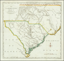
Rare, Early German Broadside Map of the North American British Colonies—First State!
First state of an remarkably rare German broadside map showing the British colonies in North America, one of the earliest separately-issued broadside maps of the colonies published during the American Revolutionary War. It is quite possibly the earliest such broadside map published outside Britain.
The map was undoubtedly published to advise the German public of the progress of the Revolutionary War—German troops were hired by the British to fight in America. On the other side of the conflict, certain factions of the German public harbored pro-American, anti-imperialist sentiments.
While the format of the map appears to be very similar to the “Theatre of War” map published by Sayer & Bennett, this map actually pre-dates the Sayer & Bennett broadside. In fact, it is based on Jonathan Lodge's “A General Map of North America being the SEAT of WAR, between the King's Troops, and the Provincials. . .,” which was "Printed according to Act of Parliament on Jany 27, 1776."
The map shows political boundaries with dotted lines and includes a detailed account of rivers, mountain ranges, settlements, and indigenous groups. These boundaries come from a number of British treaties, including:
- The north boundary of New England by the Charter of 1620
- The bounds of Carolina by the Charter of 1663
- The limits of Carolina, stipulated 1734
- The Earl of Granville’s property
Other early boundaries are noted, but unnamed. The map is smaller and a bit less thickly detailed than Lodge’s, but is a very credible presentation intended for a different audience. In the lower right corner is a distance table explaining the mileage separating principal towns and cities across the colonies.
The text below the map, in German, is organized by colonies, with sections describing:
- Quebec
- Nova Scotia
- New England
- New York
- New Jersey
- Maryland
- Virginia
- North and South Carolina and Georgia
- Pennsylvania
German troops in the American Revolution
Roughly 30,000 German troops, known as Hessians, served in the American Revolution. They were hired by the British to fight alongside the British regular troops. While many of the soldiers were from Hesse-Cassel, hence the Hessian moniker, troops actually came from a variety of German states.
It was common in eighteenth-century warfare to hire foreign troops on a large scale to fight in wars around the world. Indeed, soldiers were a major export of Hesse-Cassel and other German states—Hesse Cassel gained thirteen years of tax revenue by renting its troops to the British in the American Revolution. This allowed taxes to remain low at home and provided for public works programs that otherwise would not have been funded.
German soldiers were considered to be disciplined fighters and were respected by adversaries. This is because they were trained from a young age. At age seven they were registered for military service; men 16-30 were reviewed each year for possible induction to fight. While some men were exempt thanks to jobs that were considered vital to the state, others could be pressed into service if they were unemployed, bankrupt, or in legal trouble. In return, soldiers and their families received tax breaks, relatively high wages, and possible plunder bonuses.
At the end of the war, at least 3,000 Hessians decided to stay and start lives in the United States.
States and rarity
This is the first of two known states of the map. The map is of rare in both states, with only a few examples located in German (5, state 1), Switzerland (1, state 1), France (1, state 2), and American institutions; at least one of these lacks the text.
State 1: Has the imprint of Ritter, as shown here. Known US examples are housed at the University of Georgia and the Leventhal Map and Education Center, Boston Public Library.
State 2: Has the imprint of Möllerische Buchhandlung. The Hamburg in the imprint is darker than the first state. Examples at US institutions are at the Library of Congress, the Harvard Map Collection, and the John Carter Brown Library.
The British Library also has an example, but the imprint is not listed in their catalog.
Thomas Albrecht Pingeling (1727-1803) was a Hamburg-based engraver. The son of an engraver, Gottfried Christian Pingeling, Thomas started working for his father in 1751. He took over the business upon his father’s death in 1769 and their workshop was considered the most important in Hamburg in the second half of the eighteenth century. They had many international clients and especially strong ties with London and St. Petersburg. Later, he entered into partnership with his student, Johann Thomas Hagemann. The shop specialized in illustrations and title vignettes, as well as bookplates. They also published many maps, charts, and views.

![[HAPAG Map of the United States and Canada]](https://storage.googleapis.com/raremaps/img/small/78779.jpg)
![[Massachusetts Bay, with Boston and Part of Cape Cod]](https://storage.googleapis.com/raremaps/img/small/59282.jpg)