


|
||

|

|
|

|
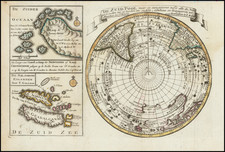
Rare map of the South Polar regions, executed by Antonio Zatta at the end of the 18th Century.
The map illustrates a number of voyages, including:
- Sir Edmund Halley in 1700
- Captain James Cook 1773-74
- Abel Tasman 1642
- Furneaux 1773
- Captain Hook ? 1769 (Cook)
Antonio Zatta (fl. 1757-1797) was a prominent Italian editor, cartographer, and publisher. Little is known about his life beyond his many surviving published works. It is possible that he was born as early as 1722 and lived as late as 1804. He lived in Venice and his work flourished between 1757 and 1797. He is best known for his atlas, Atlante Novissimo (1779-1785), and for his prolific output of prints and books that were both precisely made and aesthetically pleasing. Zatta clearly had a large network from which to draw information; this is how he was able to publish the first glimpse of the islands visited by Captain Cook in the Atlante Novissimo. Zatta also published books of plays and architecture.

![(Arctic Exploration) [Manuscript Map of Ross Expedition to King William Island and Boothia Peninsula with additional reference to George Back's 1833-34 Expedition]](https://storage.googleapis.com/raremaps/img/small/74238.jpg)