


|
||

|

|
|

|
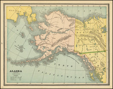
Fine set of four maps, highlighting the gold regions in Alaska and the Behring Straits, published by A.H. Petermann.
The maps including the following:
- The Klondike Gold Region
- The Seward Peninsula Gold Region
- Routes to the Klondike Gold Fields
- The Tschuktschen Peninsula
The map illustrates an article in Petermann's geographical magazine by Hauptmann Fr. Immanuel.
August Heinrich Petermann (1822-1878) is a renowned German cartographer of the nineteenth century. Petermann studied cartography at the Geographical Art-School in Potsdam before traveling to Edinburgh to work with Dr. A. Keith Johnston on an English edition of Berghaus’ Physical Atlas. Two years later he moved to London, where he made maps and advised exploratory expeditions as they set off to explore the interior of Africa and the Arctic.
In 1854, Petermann returned to Germany to be Director of the Geographical Institute of Justus Perthes in Gotha. There, he was the editor of the Geographische Mittheilungen and Stieler’s Handatlas. The Royal Geographical Society of London awarded him their Gold Medal in 1860. He continued his interest in exploration in Germany, fundraising for the German Exploring Expeditions of 1868 and 1869-70, which sought an open Arctic sea. Tragically, he committed suicide in 1878.
![[ Queen Anne's War - Failed Attack on French Canada -- Petition to Queen Anne from the Colony of New York seeking reimbursement for a failed conquest of New France during Queen Anne's War ] To the Queens most Excellent Majesty . . . 1709](https://storage.googleapis.com/raremaps/img/small/85409.jpg)
![[Map of Russian Possessions in North America] Карта Российскаго Владѣнія въ Сѣверной Америкѣ](https://storage.googleapis.com/raremaps/img/small/66569.jpg)
![Carte Reduite Des Costes Orientales De L'Amerique Septentrionale . . . contenant L'Isle Royale . . . La Nouvelle Angleterre et la Nouvelle Yorc . . . MDCCLVII [with Plan of Boston Harbor] Plan du Havre de Baston](https://storage.googleapis.com/raremaps/img/small/80006.jpg)

![[Unique Extra-Illustrated Example!] Carte Nouvelle Contenant La Partie d'Amerique La Plus Septentrionale, . . . Le Canada ou Nouvelle France, La Nouvelle Ecosse, La Nouvelle Angleterre, Les Nouveau Pais Bas, La Pensylvanie . . . Et Jle. de Terre Neuve . . .](https://storage.googleapis.com/raremaps/img/small/47720.jpg)