This item has been sold, but you can enter your email address to be notified if another example becomes available.


|
||

|

|
|

|
Stock# 4295
Description
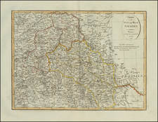
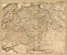
Very scarce regional map of Poland, Ukaraine and Lithuania, showing the region bounded by the Dnieper, Przypiee and Sniadin Rivers and showing Minsk, Mir, Niesziesz, Sluck, Sloboda, and Rohaczew Shows rivers, roads, towns, castles, forests, lakes and a host of other details. Quite possibly the most detailed map of this region to appear in an 18th Century Atlas. From Von Reilly's exceedingly scarce Grosser Deutscher Atlas. Von Reilley & Schaembl led a revival of map making in Vienna in the late 18th Century which included this and several other sought after works.