


|
||

|

|
|

|
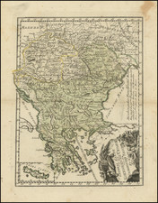
Rare separately issued map of Hungary, published by Frederick De Wit in Amsterdam.
The map is drawn from the same plate as the map of Johannes Meyssens. De Wit purchased the plate from Meyssens in about 1666, and is dated based upon a single example in a private European collection.
The map includes large views of:
- Buda (Buda vulgo Ofen)
- Bratislava (Posoniensis vulgo Presburg)
- Newheus
- Belgradum (Belgrad)
The map was drawn duing the Great Turkish War, from 1667 to 1683. Portraits of the Holy Roman Emperor Leopold I and the Turkish Sultan Mohammed IV are shown.
De Wit's map follows generally the model of the Danckerts maps of 1657 and 1663 (links below):
De Wit (1629 ca.-1706) was a mapmaker and mapseller who was born in Gouda but who worked and died in Amsterdam. He moved to the city in 1648, where he opened a printing operation under the name of The Three Crabs; later, he changed the name of his shop to The White Chart. From the 1660s onward, he published atlases with a variety of maps; he is best known for these atlases and his Dutch town maps. After Frederik’s death in 1706, his wife Maria ran the shop for four years before selling it. Their son, Franciscus, was a stockfish merchant and had no interest in the map shop. At the auction to liquidate the de Wit stock, most of the plates went to Pieter Mortier, whose firm eventually became Covens & Mortier, one of the biggest cartography houses of the eighteenth century.
![[Prague] Panorama Kralovske Prahy](https://storage.googleapis.com/raremaps/img/small/89611.jpg)

![(Manuscript Map of Budapest) Bude attacque par les ducs de Lorraine... [Buda Attacked by the Dukes of Lorraine]](https://storage.googleapis.com/raremaps/img/small/95273.jpg)