
This item has been sold, but you can enter your email address to be notified if another example becomes available.


|
||

|

|
|

|
Stock# 4293
Description
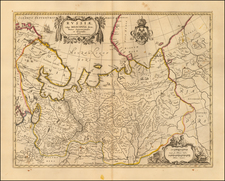
Very scarce regional map, showing area bounded by Dniester, Bruth and Moldova Rivers and including Sutzawa, Czernowitz, Sireth, Chotin, Kaminiecc Podolsky, Kyataigrod, Grodeck Mikohtschin, Hokurasza, Baja and a portion of Galitzia. Shows rivers, roads, towns, castles, forests, lakes and a host of other details. Quite possibly the most detailed map of this region to appear in an 18th Century Atlas. From Von Reilly's exceedingly scarce Grosser Deutscher Atlas. Von Reilley & Schaembl led a revival of map making in Vienna in the late 18th Century which included this and several other sought after works.
![Сны Султана (Картина 2) [Dreams of the Sultan. Scene 2]](https://storage.googleapis.com/raremaps/img/small/60238.jpg)
![[Gdansk]. Prospect, Grundris und Gegend der Polnischen velen Reichs und Handels=Stat Dantzig . . .](https://storage.googleapis.com/raremaps/img/small/35677.jpg)