|
||

|

|
|

|
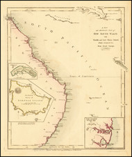
The First Detailed Mapping of the Adelaide Region.
Nice example of the first detailed map of the region around Adelaide, South Australia, published in 1811 by Louis de Freycinet.
The map is centered on Kangaroo Island (Ile Decres) and extends east to Portland (Sealers Cove) and Cape Nelson State Park (Promontorie de Wilson) and west to the area of Nullarbor National Park.
The area which is now Adelaide is identified as B. Dugueselin, C. Sully and C. Mondovi.
As reflected by the Title, the map demonstrates the French intent to colonize Australia. At the time of the Baudin voyage a Napoleonic order existed to take control of Australia by conquest.
The place names engraved on this chart maps are almost entirely in French. The second edition of Baudin's voyage published in 1824 shows most of these names changed to English.
Baudin's Atlas was the first Australian atlas ever published. Although Matthew Flinders charted this coastline at the same time as Baudin, and the two expeditions met in Encounter Bay, Flinders' publication was delayed by several years due to his imprisonment by the French on Mauritius.
The map is embellished with vignettes based on drawings by Charles Alexandre Lesueur (featuring kangaroos and sea lions reclining composed beneath an idealized neoclassical figure).
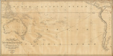
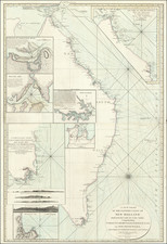
This cornerstone map shows the final result of the extensive surveying and explorations in this region undertaken by the French between 1801 and 1808, surveyed and compiled by Louis de Freycinet and made under the command of Nicolas Baudin, who cruised the region at the same time as Matthew Flinders.
Freycinet's mapping of Australia was conducted during his time in Australia as a member of the Baudin expedition. In October 1800, Nicolas Baudin commenced an expedition to the south seas to complete the French survey of the Australian coastline, and make scientific observations. The two ships, Le Geographe and Le Naturaliste, arrived near Cape Leeuwin in May 1801. By early April 1802 Baudin in Le Geographe was in South Australian waters. He sailed westward, meeting Flinders at Encounter Bay, and continuing to Golfe de la Mauvaise [Gulf St Vincent] and Golfe de la Melomanie [Spencer Gulf], giving French names to many locations already named by Flinders.
After wintering at Port Jackson, Baudin returned to the southern coast for a more detailed survey, and in January 1803 circumnavigated Ile Borda [Kangaroo Island]. While Baudin anchored at Nepean Bay, Freycinet and the geographer Boullanger explored the two gulfs. By the end of February Le Geographe and Casuarina rendezvoused at King George Sound, and then explored the west and northwest coasts of 'New Holland', before heading home via Timor.
Baudin died in 1803 on the homeward voyage, so publication of the account and charts of his voyage was undertaken by Francois Peron, the expedition's naturalist. The first volume of Voyage de decouvertes aux Terres Australes and Volume I of Atlas, which included plates, was released in 1807. French place names were recorded for 'Terre Napoleon' west of Wilson's Promontory. As Peron died in 1810, cartographer Louis de Freycinet continued to edit the voyage's account, and in 1811 he published the second part of Atlas, which featured the charts of the expedition, again recording French place names on 'Terre Napoleon.'
The French expedition's charts were published in 1811 - three years before Flinders work. Freycinet's Carte General de la Nouvelle Hollande was therefore the first chart of Australia, bringing together the results of English and French surveys. The French charts are generally acknowledged as beautiful with their elaborate title cartouches with flora and fauna.
Louis de Freycinet joined the Baudin expedition as a junior lieutenant. His duties on the expedition were as a cartographer-surveyor. While the French expedition was in Sydney from June-November 1802, Baudin acquired the Casuarina, and placed Freycinet in command. Freycinet surveyed the southern Australian coast and contiguous regions. While charting the South Australian gulfs, Freycinet missed his rendezvous with Baudin in Le Geographe, but joined him in King George Sound. They then sailed along the Western Australian coast together, before going to Timor and then Mauritius.
After returning to France, Freycinet worked on the charts and when the atlas was published in 1811, the entire unknown coast from Wilson's Promontory to the Head of the Bight was shown as Terre Napoleon, with French place names on all the prominent features. Following Péron's early death, Freycinet completed the official account of the expedition.
Louis Claude Desaulses de Freycinet (1779-1841) was a French hydrographer and explorer. He joined the French Navy in 1793. In October 1800, at the age of 21, Freycinet set off in the Naturaliste, part of an exploratory expedition to chart Australia. He was accompanied on this voyage by his brother, Louis-Henri, who would go on to become an admiral.
In Sydney, the leader of the expedition, Nicholas Baudin, purchased a 29-foot vessel. He named it Casuarina and placed Freycinet, who had proven himself an adroit hydrographer, in command. With his new charge, Freycinet was to perform inshore surveys. During the course of 1802, the Casuarina charted large portion of the southern coast of Australia.
Freycinet returned to France in 1804. Since Baudin had died in Mauritius, the naturalist Francois Peron and Freycinet were directed to prepare for publication the official account of the voyage, with an accompanying atlas. The official account appeared over ten years and in four volumes. The first narrative of the voyage, primarily by Peron, was published in 1807. The second narrative volume was published in 1816 and was written primarily by Freycinet. Peron had died in 1810. The first part of the Atlas, which contained 40 engraved plates, two of them folding, appeared in 1807. The second atlas, was published in 1811 with 14 engraved charts, two of them double-page. These double-page maps include a map of the Australian continent, the first map to show the continent in its entirety and made partially from Matthew Flinders’ papers.
His publications stemming from the Baudin expedition would have been enough to secure the fame of Louis Freycinet. However, he is perhaps best known today for his second voyage to the Pacific, one he commanded in the Uranie. From 1817 to 1820, Freycinet cruised the Pacific performing experiments and, of course, making detailed charts. He was accompanied by his wife Rose.
Although the Uranie was wrecked in the Falklands on the return journey, the natural historical specimens and geographical notes were saved. They were published in 13 volumes with 4 additional volumes of plates and maps between 1824 and 1844.
The voyage secured Freycinet a place in the Academie des Sciences. He also went on to help found the Paris Geographical Society, the first such group of its kind. Louis Freycinet died in 1841.
![[ Queensland / Papua New Guinea ] Nouvelle Guinee et Carpentarie](https://storage.googleapis.com/raremaps/img/small/98045.jpg)