|
||

|

|
|

|
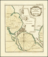
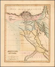
Finely detailed map of the Northwestern Branch of the Red Sea (also called Birk et Faraoun and Barkah el Gorandal), published by William Faden in London.
The map includes a prospect view of the Suez, fiew of Tor and views of Mount Agrib, Mount Sinai and Mount Horeb (drawn originally by Niebuhr), along with detailed plans of the Harbours of Suze and Tor, with some sailing directions and details of each.
The map extends from Suez to Hurghada, Jubal and Shad a Wan Island, with Ras Mohammed, Tiran Island and Sanafir Island across the Gulf, at the confluence of the Gulf of Suez and the Gulf of Aqaba.
The map identifies British naval expeditions into the region, including:
- Captain Panton, aboard the Swallow in 1777
- Lieut. Ashmed Pruen during the Grab-Snow expedition of 1778
- Eyles Irwin's track in 1777 (East India Company)
The map is one of the few to focus on the Arabic and "Turkish" names.
The map is apparently quite rare. We were only able to locate the example in the collection of the National Records of Scotland, National Maritime Museum (UK) and British Library.
William Faden (1749-1836) was the most prominent London mapmaker and publisher of the late-eighteenth and early-nineteenth centuries. His father, William Mackfaden, was a printer who dropped the first part of his last name due to the Jacobite rising of 1745.
Apprenticed to an engraver in the Clothworkers' Company, he was made free of the Company in August of 1771. He entered into a partnership with the family of Thomas Jeffreys, a prolific and well-respected mapmaker who had recently died in 1771. This partnership lasted until 1776.
Also in 1776, Faden joined the Society of Civil Engineers, which later changed its name to the Smeatonian Society of Civil Engineers. The Smeatonians operated as an elite, yet practical, dining club and his membership led Faden to several engineering publications, including canal plans and plans of other new engineering projects.
Faden's star rose during the American Revolution, when he produced popular maps and atlases focused on the American colonies and the battles that raged within them. In 1783, just as the war ended, Faden inherited his father's estate, allowing him to fully control his business and expand it; in the same year he gained the title "Geographer in Ordinary to his Majesty."
Faden also commanded a large stock of British county maps, which made him attractive as a partner to the Ordnance Survey; he published the first Ordnance map in 1801, a map of Kent. The Admiralty also admired his work and acquired some of his plates which were re-issued as official naval charts.
Faden was renowned for his ingenuity as well as his business acumen. In 1796 he was awarded a gold medal by the Society of Arts. With his brother-in-law, the astronomer and painter John Russell, he created the first extant lunar globe.
After retiring in 1823 the lucrative business passed to James Wyld, a former apprentice. He died in Shepperton in 1826, leaving a large estate.