|
||

|

|
|

|
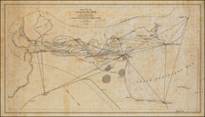
Rare British Admiralty chart depicting San Luis pass at the southern end of Galveston Island.
The chart was drawn by Captain Addison Hinton of the Texas Navy during the Republic era and depicts numerous anchorages, soundings and shoals.
This is one of the few charts we have seen which credits an officer of the Navy of the Republic of Texas with the creation of a sea chart
Addison C. Hinton served for seven years in the United States Navy before moving to Texas in 1837. He first worked for three months as a clerk, read law in Houston, and in 1837 joined the Texas Navy. He was commissioned a commander and in April 1839 was appointed captain of the Zavala, the first steam man-of-war in the Gulf and probably the first Hinton had ever seen. From September until November 1839 he also commanded the San Bernard.
In the summer of 1839 he is reported to have saved the French vessel Phaeton from wrecking, but the French "Society of Wrecks" awarded its medal to Edwin W. Moore as a reward for that action. On October 29, 1839, Hinton was ordered to New Orleans to have the Zavala refitted and to recruit crews for his own and other ships of the Texas Navy. At the time he knew little of mechanics, finance, or diplomacy. He was able to enlist but few recruits, and many of his own men deserted. After running up $14,000 in repair charges beyond what he had been authorized to spend, he was dismissed from the navy on February 6, 1840, and returned to Texas hurt and bitter.
John T. K. Lothrop succeeded him in command of the Zavala. Hinton made several attempts to gain reinstatement in the service; in 1841 the Congress of the Republic of Texas determined that the Navy could not dismiss an officer without a court-martial. Hinton was thereupon cleared of any wrongdoing but was not reinstated. He was elected justice of the peace in Galveston on March 1, 1841, and was known to be in New Orleans in February 1843.
The British Admiralty has produced nautical charts since 1795 under the auspices of the United Kingdom Hydrographic Office (HO). Its main task was to provide the Royal Navy with navigational products and service, but since 1821 it has also sold charts to the public.
In 1795, King George III appointed Alexander Dalrymple, a pedantic geographer, to consolidate, catalogue, and improve the Royal Navy’s charts. He produced the first chart as the Hydrographer to the Admiralty in 1802. Dalrymple, known for his sticky personality, served until his death in 1808, when he was succeeded by Captain Thomas Hurd. The HO has been run by naval officers ever since.
Hurd professionalized the office and increased its efficiency. He was succeeded by the Arctic explorer Captain William Parry in 1823. By 1825, the HO was offering over seven hundred charts and views for sale. Under Parry, the HO also began to participate in exploratory expeditions. The first was a joint French-Spanish-British trip to the South Atlantic, a voyage organized in part by the Royal Society of London.
In 1829, Rear-Admiral Sir Francis Beaufort was appointed Hydrographer Royal. Under his management, the HO introduced the wind force scale named for him, as well as began issuing official tide tables (1833). It was under Beaufort that HMS Beagle completed several surveying missions, including its most famous voyage commanded by Captain FitzRoy with Charles Darwin onboard. When Beaufort retired in 1855, the HO had nearly two thousand charts in its catalog.
Later in the nineteenth century, the HO supported the Challenger expedition, which is credited with helping to found the discipline of oceanography. The HO participated in the International Meridian Conference which decided on the Greenwich Meridian as the Prime Meridian. Regulation and standardization of oceanic and navigational measures continued into the twentieth century, with the HO participating at the first International Hydrographic Organization meeting in 1921.
During World War II, the HO chart making facility moved to Taunton, the first purpose-built building it ever inhabited. In 1953, the first purpose-built survey ship went to sea, the HMS Vidal. Today, there is an entire class of survey vessels that make up the Royal Navy’s Hydrographic Squadron. The HO began to computerize their charts in the late 1960s and early 1970s. In 1968, the compilation staff also came to Taunton, and the HO continues to work from there today.
![(Panoramic photograph) Camp Travis, Tex. 9/8/1918 East Side [WWI Camp Travis, near San Antonio, Texas, African American Troops]](https://storage.googleapis.com/raremaps/img/small/87312.jpg)
![(Republic of Texas Land Title) [Spanish-Mexico land sale document, 1838, Nacogdoches, Texas] Benta de un solar de tierra que hisieron Maria Tiburcia Ybarro y Maria Trinidad Ybarro a Juan S. Roberts. Nacogdoches](https://storage.googleapis.com/raremaps/img/small/88918.jpg)