


|
||

|

|
|

|
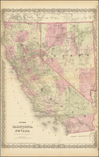
Remarkable large format map of California and Nevada. Substantial parts of California are now surveyed by the US General land Office, although Nevada is largely unsurveyed.
Riverside, Orange, Imperial and a few other counties are still lacking in the south. Many towns, rivers, lakes, mountains, forts, mining districts, Indian information, railroads, stations, etc. are shown.
One of the best large format maps of the period, from a rare late edition of Colton's atlas.
G. W. & C. B. Colton was a prominent family firm of mapmakers who were leaders in the American map trade in the nineteenth century. The business was founded by Joseph Hutchins Colton (1800-1893) who bought copyrights to existing maps and oversaw their production. By the 1850s, their output had expanded to include original maps, guidebooks, atlases, and railroad maps. Joseph was succeeded by his sons, George Woolworth (1827-1901) and Charles B. Colton (1831-1916). The firm was renamed G. W. & C. B. Colton as a result. George is thought responsible for their best-known work, the General Atlas, originally published under that title in 1857. In 1898, the brothers merged their business and the firm became Colton, Ohman, & Co., which operated until 1901, when August R. Ohman took on the business alone and dropped the Colton name.
![(San Diego -- WWI Panoramic Photograph) Camp Kearny. Co. M. 158th Infantry [World War I panoramic group portrait of U.S. Army Infantryman at Camp Kearny, San Diego]](https://storage.googleapis.com/raremaps/img/small/91707.jpg)
![[Coastal Orange County] Santa Ana Quadrangle](https://storage.googleapis.com/raremaps/img/small/83561.jpg)
![Mexique par Th. Duvotenay…1842 [Republic of Texas]](https://storage.googleapis.com/raremaps/img/small/93713.jpg)
![[Fruit Crate Label Advertising Map] Star of California Brand](https://storage.googleapis.com/raremaps/img/small/41396.jpg)