
The item illustrated and described below is sold, but we
have another example in stock. To view the example which
is currently being offered for sale, click the
"View Details" button below.
1893 Hoffman Bros
$ 1,200.00


|
||

|

|
|

|
Stock# 42523
Description
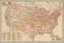
Rare separately issued map of the United States, apparently the earliest printed map to identify the various Catholic Church Provinces and Dioceses within the United States.
Each of the Provinces are divided by Dioceses, such a the Vicariate-Apostolic of Arizona and the Diocese of Savannah (Georgia), etc. Nearly 100 Dioceses are shown.
While we note later maps of the US showing the Catholic Provinces and Dioceses of the same title (M.H. Wiltzius & Co., 1899), the present map is extremely rare. We note only the example at Benedictine College in Kansas.
Condition Description
With stamp of the Jesuit Chuch and ink stamp at lower right.
![[United States] Etats-Unis](https://storage.googleapis.com/raremaps/img/small/62774.jpg)
![[Los Angeles Olympic] O Limp Hicks Loose Anglaise Calif. 1932](https://storage.googleapis.com/raremaps/img/small/90509.jpg)
![[Early Montana Territory Shown Above Idaho] Johnson's New Military Map of the United States Forts, Military Posts & all the Military Divisions with Enlarged Plans of the Southern Harbors . . . (Shows Military Departments)](https://storage.googleapis.com/raremaps/img/small/93868.jpg)