![[ Postal Map of India ] India Shewing The Post Roads And Dawk Stations By James Wyld . . . By James Wyld](https://storage.googleapis.com/raremaps/img/small/99685.jpg)


|
||

|

|
|

|
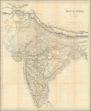
First separately issued edition of this important postal and transporation map of India, published in London by James Wyld and first appeared in Wyld's atlas in 1849.
Highly detailed map of India, focusing on the Post Roads and Dawk Stations, published shortly after the construction of the first Indian Railroads.
The key lists the following:
- Post and Banghy Roads
- Post Roads & Routes
- Banghy Roads
- Railroads
James Wyld Sr. (1790-1836) was a British cartographer and one of Europe’s leading mapmakers. He made many contributions to cartography, including the introduction of lithography into map printing in 1812.
William Faden, another celebrated cartographer, passed down his mapmaking business to Wyld in 1823. The quality and quantity of Faden’s maps, combined with Wyld’s considerable skill, brought Wyld great prestige.
Wyld was named geographer to Kings George IV and William IV, as well as HRH the Duke of York. In 1825, he was elected an Associate of the Institution of Civil Engineers. He was one of the founding members of the Royal Geographical Society in 1830. Also in 1830, his son, James Wyld Jr., took over his publishing house. Wyld Sr. died of overwork on October 14, 1836.
James Wyld Jr. (1812-87) was a renowned cartographer in his own right and he successfully carried on his father’s business. He gained the title of Geographer to the Queen and H.R.H. Prince Albert. Punch (1850) described him in humorous cartographic terms, “If Mr. Wyld’s brain should be ever discovered (we will be bound he has a Map of it inside his hat), we should like to have a peep at it, for we have a suspicion that the two hemispheres must be printed, varnished, and glazed, exactly like a pair of globes.”
![[Portrait] L'Asie.](https://storage.googleapis.com/raremaps/img/small/79746.jpg)