


|
||

|

|
|

|
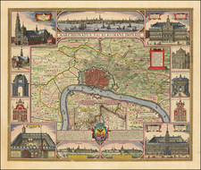
Striking carte-a-figures style plan of the city of Antwerp in Belgium, by Claes Jansoon Visscher and first published by his son.
One of the most beautiful maps of Antwerp, glorifying the beauty and the richness of the city. The map is surrounded by 3 city views and 10 building vignettes.
Includes an inset map of the southern region of Brabant, and surrounded by views of important buildings. Above the title appears a detailed panorama of the city from the river, with busy shipping; below are two further panoramas of the city from the direction of Brussels and Breda. With historical notes in Latin and Dutch.
Details include river traffic, fields of livestock outside the city walls, and busy crowds of people or admiring figures within most of the surrounding views.
The present example includes the name of Petrus Schenk Jr.
Peter Schenk the Elder (1660-1711) moved to Amsterdam in 1675 and began to learn the art of mezzotint. In 1694 he bought some of the copperplate stock of the mapmaker Johannes Janssonius, which allowed him to specialize in the engraving and printing of maps and prints. He split his time between his Amsterdam shop and Leipzig and also sold a considerable volume of materials to London.
Peter Schenk the Elder had three sons. Peter the Younger carried on his father’s business in Leipzig while the other two, Leonard and Jan, worked in Amsterdam. Leonard engraved several maps and also carried on his father’s relationship with engraving plates for the Amsterdam edition of the Histoire de l'Académie Royale des Sciences.