|
||

|

|
|

|
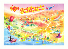
Interesting pictorial map of the Gustine, California, surrounded by local advertising, published by the Gustine Chamber of Commerce.
While published in 1975, the map is a stylistic throwback to the pictorial maps of earlier times.
The map was produced by the Ken Givens Advertising Company of Modesto, California.
The map notes:
Gustine-located on Highways 33 and 140, adjacent to Interstate Highway 5. Founded by Henry Miller in 1905 and named after his daughter Augustine, and was incorporated in 1915. A city of wide tree shaded streets with neatly tended lawns and gardens makes Gustine an ideal place to live. A farming community noted for its milk processing plants and manufacturing locations, with excellent drainage, water and sewage disposal. The community is served by national rail, bus and trucking lines. The city offers manufacturers a lower investment rate and all the facilities to keep production up and costs down. Nearby is the famous San Luis Reservoir with its storage facility for excess water from the Delta area, fed by streams of the Sierra Range during the Spring and Winter runoff. Ideal fishing and camping spots available. Gustine, a city of pride, in its city, its people and the products it produces.
![[ Original Artwork - 37 Hand Drawn Maps By Norton Allen For Desert Magazine ]](https://storage.googleapis.com/raremaps/img/small/99899.jpg)