|
||

|

|
|

|
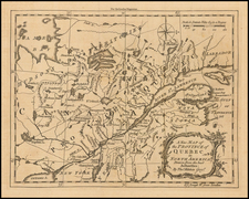
The first complete accurate general map of New Brunswick, a large folding wall map compiled by John Wilkinson and published by James Wyld.
Wilkinson's map represents the first comprehensive general map of the Province of New Brunswick. It is based on the careful compilation of the very best official surveys, produced the province's surveyor general, John Wilkinson, supplemented with new surveys conducted by him personally. Importantly, it is the first general map of the province to include the results of admiralty surveys, boundary surveys, and the accumulated cadastral mapping archived at the crown land office.
Wilkinson's map is also the first detailed general map to show New Brunswick with its final boundaries, in the wake of the resolution of its border disputes with Maine and Quebec, and the first to show New Brunswick's embryonic railway system. In terms of both its design and accuracy, the map is one of the very finest regional North American maps of its era and is a monument in the historical cartography of Eastern Canada.
The map covers New Brunswick and large portions of Maine, Quebec, Nova Scotia and Prince Edward Island. New Brunswick is shown divided into counties, which are further subdivided into townships, while a detailed road network traverses the countryside. The province's shorelines and waterways are captured with great accuracy, the outlines of which are generally fixed by trigonometric surveys, regulated by astronomical observations.
The map also delineates the newly completed railway line, which ran from St. John northeastwards, through Moncton, to Shediac Harbour, on the shores of the Cumberland Strait (finished in 1857) and the partially completed line of the New Brunswick & Canada Railway (which by thus had been built from St. Andrew's to a point up near Woodstock), which would shortly provide a connection to Quebec City.
Included on the map is a large inset, in the lower right, entitled 'Chart (on Mercator's projection) showing the relative geographical position of New Brunswick and of the several provinces forming part of British America, with the shortest sailing distances to the British Islands', which places New Brunswick within its greater geographical context within North American and the Atlantic World. Its main purpose is to show the province as occupying a particularly strategic position with regards to Trans-Atlantic trade. Interestingly, the inset depicts the 'Line of the Electric Cable', referring to the brand new Transatlantic Telegraph Cable, which would only be rendered operational on August 16, 1858, thus revolutionizing global communications.
In the lower left, the map features a series of tables under the heading 'Statistical Memoranda', that grants an extremely detailed and up-to-date quantitative profile of New Brunswick's demographics, economy, and transport systems. Notably, it states that the province's population was at the time approaching 233,900 (1860 estimate) and remarking (perhaps surprisingly) that the St. John River's ice-free navigation season is only 21 days shorter than that of New York's Hudson River. During this period, New Brunswick's economy was booming, from shipbuilding, lumber and maritime trade.
The map was widely admired during its time and it remained the authoritative general map of the province used for the remainder of the 19th Century. W.F. Ganong, the foremost contemporary authority on New Brunswick cartography, wrote in 1897:
In 1858 we come to what is generally regarded as the greatest map which has yet been published of New Brunswick - that of John Wilkinson. This map is very well known and many copies of it are still in use. Not only is it remarkable for the beauty of its workmanship, but also the completeness with which it beings together everything then known of New Brunswick geography. On it, for the first time on a New Brunswick map, a railroad, that from St. John to Shediac, appears. There has been little to alter on this map since then… (Ganong, 'A Monograph of the Cartography of New Brunswick,' p.403)
On another occasion, Ganong opined that the Wilkinson map was "scientifically constructed, minutely correct," and "beautifully engraved," and "must ever remain a classic of New Brunswick Cartography." (W.F. Gagong, "The province of New Brunswick," chap. 1, sect.3, f. 6, New Brunswick Museum & Archives, Ganong Mss. Collection, Box 37, cited by W.A. Spray).
History of the Map
In 1855, the New Brunswick Legislature commissioned the province's surveyor general, John Wilkinson, to compile an accurate general map of the entire province. The imperative for the creation of the map was quite urgent, as no map existed which presented a detailed overview of the province as a whole. This reality was causing daily problems for both government planners and commercial investors. During this period, which saw a major infrastructure boom, in roads, telegraphs and railways, route planning was impaired by the lack of a general map. Limited geographical knowledge of the province's interior and northern areas was impairing the land registry system. Beyond that, the British North American colonies were under a continual threat of attack from the United States (not an unjustified concern, as the 1866 Fenian Raids on New Brunswick would prove) and the Royal Army did not possess a decent map with which to deploy troops and plan operations.
At first, it may seem surprising that an accurate and complete general map of New Brunswick was not competed until 1858. Indeed, the province was one of the last regions of the Atlantic Seaboard to be comprehensibly mapped, although, as we shall see, there were good explanations for this. The earliest and, prior to Wilkinson, only attempt to create an accurate general map of the province was Thomas Bonner's Map of the Province of New Brunswick (London, 1820). While it projected decent coverage of the province's populated southern regions, it provided desultory coverage of the northern half of the colony. The truth remained that while parts of New Brunswick had been mapped to the highest standards by some of the world's most talented surveyors, until Wilkinson, nobody had undergone the effort to place the various surveys together into a coherent whole.
Fortunately, Wilkinson had excellent source material to work with. During the 1760s and 1770s, New Brunswick's maritime coasts had been charted to an amazing degree of accuracy for the time by teams working under the great surveyors Samuel Holland and J.F.W. Des Barres. These surveys were subsequently fine-tuned by Thomas Backhouse, in the 1790s, and by Captain William Fitzwilliam Owen from 1842 to 1847. As such, New Brunswick's' shorelines were amongst the best charted in all of the Americas.
The mapping of the Lower St. John Valley was first executed to a high standard by Captain Joseph Peach in 1760. The valley, the province's vital corridor of inland transport and main locus of fine agriculture, was subsequently mapped piecemeal to high scientific standards though cadastral surveys conducted for Loyalists settlers and their decedents. Moreover, many areas near the Bay of Fundy, in Charlotte County and the St. John and Moncton areas had been similarly mapped. These surveys were lodged in the Crown Land Office in Fredericton, overseen personally by Wilkinson.
Beyond that, the regions marking the borderlands between New Brunswick, the U.S. State of Maine and the fellow British Province of Canada East (Quebec) had been exhaustively surveyed, owing to long-standing boundary disputes. The New Brunswick-Maine Boundary Dispute was one of the longest running and most heated in North American history, lasting from 1783 until 1842. During this period, innumerable surveys of the disputed borderlands were made by several leading British and American surveyors, ensuring that these areas were excellently mapped. After much diplomatic wrangling, which nearly broke out into armed conflict (the so-called 'Aroostook War' of 1838-9), the final boundary was settled by the Webster-Ashburton Treaty of 1842.
Likewise, the New Brunswick-Quebec boundary was long contested, with Quebec claiming much of what would become New Brunswick's Restigouche and Upper St. John Valley regions. This dispute was fully resolved only in 1855, following a decision of the British Privy Council.
In the early 1840 and 1850s, Wilkinson personally surveyed the lines of the St. John-Shediac Railway and the proposed railroad from St. John to Calais, Maine. He also surveyed many telegraph line routes and county boundaries, all though trigonometric methods.
Given the numerous fine mapping programs that had been conducted in New Brunswick up to the 1850s, it is curious that no comprehensive accurate general map of the entire province had been created before 1858. The cause for this seems to be mainly due to the fact that the perennially cash-strapped New Brunswick government continually had to pay for expensive surveys relating to jurisdictional boundary disputes, property claims and surveys of infrastructure routes. These 'incidental' projects drained resources, and while they eventually contributed greatly to the creation of Wilkinson's map, for decades they caused the province's surveyor general's office to become lost in the details, instead of capturing the larger picture. Only when the need for the map reached near emergency proportions was the project finally undertaken.
Wilkinson dedicated the better part of two years, from 1856 to 1857, compiling the manuscript leading to the present map, which upon completion was dispatched to James Wyld in London. Wyld, the Royal Geographer to Queen Victoria and Prince Albert, specialized in publishing large colonial surveys (his maps of India, Australia, South Africa, as well as other parts as Canada are of great historical importance).
A second edition of Wilkinson's map, entitled Map of the British province of New Brunswick from the best existing material; by authority of the Provincial Legislature: with adjacent parts of Canada, Nova-Scotia & Maine, was issued in London by the firm of Edward Stanford in 1859. This edition is likewise rare.
John Wilkinson: Enterprising Surveyor General
John Wilkinson (1804 - 1871) was a highly talented surveyor, engineer and draughtsman who originally hailed from Yorkshire, England. He received an exceptionally fine education, graduating from the Institution of Engineers in London.
In 1830, Wilkinson moved to New Brunswick to serve as the manager of the Owen family estate on Campobello Island in Passamaquoddy Bay. There he became acquainted with the family's patriarch, the eminent hydrographer William Fitzgerald Owen (1774-1857), who recommended Wilkinson's talents to provincial authorities in Fredericton.
In 1836, Wilkinson was appointed senior surveyor and draughtsman under Thomas Baillie, the province's chief commissioner of crown lands and surveyor general. From 1840 to 1843, he was engaged in mapping the New Brunswick-Maine Boundary. In 1844, he surveyed the intended route of the proposed Saint John-Shediac Railway and in 1850, he mapped the line of the planned Saint John-Calais Railway. He was also engaged in a variety of other infrastructure surveys, as well as jurisdictional boundary and cadastral mapping.
Wilkinson's biographer, W.A. Spray, correctly summed up his contribution to the mapping of New Brunswick during this period, noting that "Wilkinson was an extremely careful and accurate surveyor, and his plans in the crown land office are by far the best in their extensive collection."
Promoted to become the Surveyor General of New Brunswick, Wilkinson compiled the Map of the British Province of New Brunswick (1858). While the map was met with universal praise, Wilkinson became embroiled in an acrimonious dispute with the crown over his fees for the project and the copyright of map. In 1864, the courts ruled in the government's favour and Wilkinson angrily resigned his post. He was subsequently engaged as an engineer-inspector of bridges and lighthouses for the provincial Board of Public Works. Wilkinson died in Fredericton in 1871.
The present first edition of Wilkinson's map of New Brunswick is today very rare. While a decent print run was likely issued by Wyld, as Ganong noted, examples of the map were heavily used and the survival rate of such large wall maps is quite low. We locate 7 institutional examples (Yale, Huntington, Michigan-Clements, Toronto-Fisher, Library & Archives of Canada, U.K. National Archives and the New Brunswick Museum & Archives) and, as far as we are aware, the last time that another example of either edition of the map appeared on the market was in 1991 (D & E Lake Rare Books, Toronto).
The description was created by Alexander Johnson for Antiquariat Dasa Pahor.
Includes "Chart (on Mercator's projection) shewing the relative geographical position of New Brunswick and of the several provinces forming part of British America, with the shortest sailing distances to the British Islands."

![Partie du Cours du Fleuve de Saint Laurent depuis Quebec jusqu'au Cap aux Oyes [on sheet with] Carte du Cours du Fleuve Saint Laurent depuis Quebec jusqu'a la Mer en Deux Feuilles ... 1761](https://storage.googleapis.com/raremaps/img/small/55185.jpg)
![Amer. Sep. No. 24. Nouveau Cornouailles [Prince Rupert, Babine Lake &c]](https://storage.googleapis.com/raremaps/img/small/1783RB.jpg)