


|
||

|

|
|

|
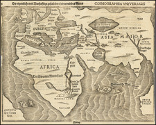
Fine example of Antonio Floriano's rare separately issued two sheet map of the World, believed to have been published in Venice, some time between 1545 and 1555.
The map is based upon Gerard Mercator's double-cordiform map of 1538 (Shirley 74), of which there are only 2 known surviving examples. Cartographically, the map dates to the period between 1545 and 1550 and there is strong evidence to suggest that the map is drawn directly from Antonio Salamanca's 1550 copy of the 1538 Mercator map (Shirley 91). In the top corners of the map are circular portraits of Ptolemy and Floriano himself, the two lower corner spaces are left blank.
America is shown as being entirely separate from Asia, and divided into two labeled continents, north and south. Both the North Pole and South Pole consist of an enormous landmass.
It is known that in 1555, Antonio Floriano of Udine addressed himself to the Doge of Venice to obtain a privilege to print a map of the world. Floriano wrote:
I, Florian, the very loyal servant of Your Highness and of this Illustrious Republic, with my diligence and knowledge having made a mappemonde which has never been made before, with the aid of which one can easily study and learn cosmography and see the entire picture of the world, since it can be reduced to spheric form.
Floriano also claimed that the map was made by him "with so much drudgery and sweat, with more heavy toil Your enlightened judgement can imagine." As noted in Arkway Catalog 54,
The result of Floriano's toil is this rare and unusual map depicting the two hemispheres each cut into thrity-six gores comprising 10 degrees of longitude each. In spite of its unique appearance, Floriano's map is directly based on Mercator's double-cordiform map of 1538 with the geography and place names taken from Mercator without change. Even the system of projection is identical to that of Mercator if the individual gores are considered one by one. "Still, the Udinese artist has the merit of having made a world map in gores rather different from that of the Mappa Mercatoriana and had tried a new manner for projecting the globe" -- Imago Mundi.
The exact date of the map has been the subject of debate. While it is known that Floriano was granted a privilege by the Venetian state to prepare and publish a world map in January 1555 (see above), several authorities have questioned whether the privilege applies to this map, noting that the geographic information suggests a date of sometime between 1545 and 1550. The engraving has been attributed to Paolo Cimerlino, due to the monogram that appears next to the portrait of Ptolemy.
The map is exceedingly rare, with only a few examples appearing on the market in the past 30 years.
his Mappemonde’ by Rudolfo Gallo, pp. 35-38.
![Ленин – вождь международного пролетариата [Lenin – Leader of the International Proletariat]](https://storage.googleapis.com/raremaps/img/small/93242.jpg)
![[Grotto of Tethys -- Versailles] Le Soleil qui se couche dans la mer / Le Globe de la Terre, divise en six parties.](https://storage.googleapis.com/raremaps/img/small/79606.jpg)
![[World] Generale Ptholemei](https://storage.googleapis.com/raremaps/img/small/94338.jpg)