|
||

|

|
|

|
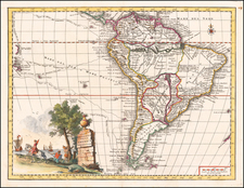
The "First Correct Delineation of a Great Part of the Shores" of South America, based upon the most important Spanish Scientific Expedtition of the 18th Century.
First state of this rare separately issued English sea chart of the southern coastlines of South America, published in London by William Faden in 1802.
A remarkable large format map of the coast of South America, apparently drawn primarily from the work of Malaspina during his time in command of Descubierta and Atrevida, twin corvettes of the Spanish Navy, custom-designed as identical special exploration and scientific research vessels. Both ships were built at the same time for the Malaspina Expedition.
Under the command of Alessandro Malaspina ( Descubierta) and José de Bustamante y Guerra ( Atrevida) the two vessels sailed from Spain to the Pacific Ocean, conducting a thorough examination of the internal politics of the American Spanish Empire and the Philippines.
The chart extends from Buenos Ayres to the Diego Ramirez Islands south of Cape Horn, back north to Valparaiso, Santiago and the Isles of Juan Fernandes, highlightling Carteret's and Magellan's tracks through these islands. Along the majority of the coastline, the tracks of Captain James Cook in 1773-75 are shown, along with Anson (1742).
Of primary note are the explorations and tracks of the Malaspina Expedition. Malaspina's expedition was the most important voyage of discovery dispatched by Spain in the 18th century. It had two primary goals, the first being to increase geographic and scientific knowledge in general, the second being to check on the status of Spain's vast empire, especially along the west coast of North America, where the Russians and the British were expanding their influence. Modeled after the voyages of James Cook, the Malaspina expedition was conducted in a highly scientific manner. Numerous scientists from many fields were among the crew. Indigenous peoples, such as the Tlingit and Tongan, were studied by the expedition's ethnographers.
The Descubierta and Atrevida sailed from Cadiz on July 30, 1789, stopping first at Montevideo on the Río de la Plata, then sailing south along the coast of Patagonia and visiting the Falkland Islands (Islas Malvinas). After rounding Cape Horn the expedition stopped at several Chilean ports and surveyed the Juan Fernández Islands. The two corvettes sailed north separately, surveying and mapping the coast between Peru and Mexico, where they arrived at the end of March 1790, before heading north toward California and Alaska.
The map includes a number of large insets, and provides a fine accounting of the known and unknown coastlines.
The map is referenced as one of the source maps utilized by Spix & Martius during their travels in South America.
The following description of the chart appeared in The Critical Review; or Annals of Literature. Vol XXXIV. . . . London: Printed By and For S. Hamilton . . . 1802, in the Review of Maps and Charts, section, at page 585-86.
Chart of the Coasts of South America, from Rio de la Plata to Cape Horn, and from Cape Horn to Valparayso, including the Isles of Juaff Pernandes. Two Sheets. 15s. Faden.
To the title of this chart is annexed the following information:
The Spanish chart from which almost the whole of the present is a faithful copy has been geometrically surveyed by royal order in the years 1789, 90, 94, and 95 ; and presented to his Catholic majesty in 1798 by Don Juan de Langara, minister of marine. That excellent original extends only from the parallel of 36° 30' of south latitude to Cape Horn, and goes not beyond the meridian of 76° 42' west of Greenwich. A greater extension given to this copy in latitude and longitude has enabled us to insert the Isles of Juan Fernandes, which are of some interest to our navigators in the South Sea. We have added, besides, various plans of harbours and roads, appearances of land, tracks of ships, with their soundings, &c. and several other particulars. The improvements made on the south coast of Tierra del Fuego, and omitted by the Spanish hydrographer, might be equally mentioned, could their small importance make them remarkable in a series of discoveries which so eminently increase our geographical knowledge.
The Spanish survey here mentioned must be that by Malespina, whose name, we understand, is, on account of some slight difference or jealousy, affectedly passed in silence by the Spanish council of marine. The present chart is extremely interesting, as it is founded on the first correct delineation of a great part of the shores of the new continent; and it varies considerably from the charts and maps before published. In the first sheet there are plans and views of Juan Fernandes, &c. with a small chart of the north part of Saint George's Bay, and others of Sea-Bear Bay and Port Saint Elena. The southern sheet also contains several views of land and plans of ports. A remarkable feature of the southern part is the large island of Campana, lat. 480, and the Campana channel, which divides it from the main land of New Chili.
A later edition of the chart exists, published in 1821, in the National Library of Brazil and John Carter Brown Library. Eleven of the insets were retained in the 1821 publication of this chart, except for "Berkley's Sound called by the Spaniards Puerto de la Soledad and by the French Baie d'Accaron," which was replaced by "Berkley Sound (in Falkland Island.) ... by A. Robson. 1819."
The Faden chart is extremely rare. OCLC locates only the British Library and John Carter Brown copies of the 1802 edition.
A references to the chart appears in Mapoteca Colombiana, the Catalog of the New York State Library (1855-56, Vol 3, p.80) and Katalog der Commerz-Bibliothek in Hamburg (1864), however, the survival of these examples is unknown.
The first example of this highly important chart we have seen and quite possibly the first appearance on the market in many decades.
William Faden (1749-1836) was the most prominent London mapmaker and publisher of the late-eighteenth and early-nineteenth centuries. His father, William Mackfaden, was a printer who dropped the first part of his last name due to the Jacobite rising of 1745.
Apprenticed to an engraver in the Clothworkers' Company, he was made free of the Company in August of 1771. He entered into a partnership with the family of Thomas Jeffreys, a prolific and well-respected mapmaker who had recently died in 1771. This partnership lasted until 1776.
Also in 1776, Faden joined the Society of Civil Engineers, which later changed its name to the Smeatonian Society of Civil Engineers. The Smeatonians operated as an elite, yet practical, dining club and his membership led Faden to several engineering publications, including canal plans and plans of other new engineering projects.
Faden's star rose during the American Revolution, when he produced popular maps and atlases focused on the American colonies and the battles that raged within them. In 1783, just as the war ended, Faden inherited his father's estate, allowing him to fully control his business and expand it; in the same year he gained the title "Geographer in Ordinary to his Majesty."
Faden also commanded a large stock of British county maps, which made him attractive as a partner to the Ordnance Survey; he published the first Ordnance map in 1801, a map of Kent. The Admiralty also admired his work and acquired some of his plates which were re-issued as official naval charts.
Faden was renowned for his ingenuity as well as his business acumen. In 1796 he was awarded a gold medal by the Society of Arts. With his brother-in-law, the astronomer and painter John Russell, he created the first extant lunar globe.
After retiring in 1823 the lucrative business passed to James Wyld, a former apprentice. He died in Shepperton in 1826, leaving a large estate.

![[Unusual Italian Immigrant Communities shown!] America Settentrionale, Centrale e Meridionale -- Carta Dimostrativa Delle Ambasciate, Legazioni, Consolati (Con Le Risettive Circoscrizioni Territoriali), Camere Di Commercio, Agenzie Commerciali, Stazion Enotecniche, Uffici Postali, Ospedali, Scuole Governative e Sussidiate All'Estero](https://storage.googleapis.com/raremaps/img/small/86098.jpg)