|
||

|

|
|

|
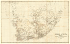
Important early map of South Africa, drawn from Henry Hall's map of 1856.
Highly detailed map of South Africa, showing towns, rivers, roads, mountains, lakes and a host of other information.
Henry Hall (1815-1882) was born in Dublin in 1815 and moved to Cape Colony in 1842, in the employ of the British Government Service, a Foreman of Works in the Royal Engineer Department. Hall served on the Eastern Frontier during the Frontier Wars of 1846 and 1851-52. In 1852 he returned to England briefly, but returned to the Cape Colony until 1860.
Henry Hall's contribution to the Cartographic history or South Africa was described first by South African Journalis S.A. Rochlin in 1962 and later in a comprehensive paper written by Elri Liebenberg, for the International Symposium entitled "Old Worlds-New Worlds": The HIstory of Colonial Cartography 1750-1950 (Utrecht University, August 2006).
A link to the Liebenberg article can be found below. Liebenberg notes:
In 1856 Stanford's Geographical Establishment in London published Henry Hall's comprehensive Map of the Eastern Frontier of the Colony of the Cape Good Hope. Compiled from local authoritative information only, this map not only surpassed its predecessors in scale and completeness, but also achieved a marked degree of accuracy. In 1857, Hall became the first resident cartographer to publish a map of the entire African region south of 16°S. Entitled South Africa , this map was the first of its kind ever to be produced in South Africa as not only the compilation, but also the engraving, printing, colouring and mounting were undertaken locally. In 1859 Stanford's published two additional maps under Hall's name: one of the subcontinent south of 25° 30'S entitled South Africa, and another entitled Map of South Eastern Africa from Algoa to Delagoa Bay.
In spite of Henry Hall's rightful claim to fame as South Africa's foremost pioneer cartographer, little has been published on his cartographical work. This paper discusses his contribution to South African geography and cartography by reviewing his maps against the background of the available topographical information and the political situation of the day. Attention is given to his source material; his hitherto little known manuscript maps of South Africa in the British National Archives (BNA) and Cape Archives Repository (CAR); the significance of his published maps and his textbook on the geography of South Africa; his supervision of Thomas Baines' 1876 Map of the Goldfields of South Eastern Africa and his involvement with the official 1876 Map of the Cape of Good Hope and some divisional maps of the southwestern Cape compiled by the Surveyor-General.
www.icahistcarto.org/PDF/Liebenberg_Elri_-_The_Cartography_of_Henry_Hall.pdf
Edward Stanford (1827-1904) was a prominent British mapmaker and publisher. A native of Holborn in the heart of London, Edward was apprenticed to a printer and stationer at the age of 14. After his first master died, he worked with several others, including Trelawny W. Saunders of Charing Cross. Saunders oversaw young Edward’s early career, ensuring that he became a Fellow of the Royal Geographical Society. Associations with the Society eventually brought Sanders much business and gave him a reputation as a publisher of explorers. As testament to this reputation, the Stanford Range in British Columbia was named for him by John Palliser.
Stanford briefly partnered with Saunders in 1852 before striking out on his own in 1853. He was an agent for the Ordnance Survey, the Admiralty, the Geological Survey, the Trigonometrical Survey of India, and the India Office. He also controlled the maps of the Society for the Diffusion of Useful Knowledge, another lucrative source of income. In 1857, Stanford founded his namesake Geographical Establishment, with Saunders and A. K. Johnston as engravers. Thereafter, Stanford was known for his “library maps”, particularly those of Africa and Asia.
Addresses and Years of Operation:
- 6 Charing Cross, London (1848): Edward Stanford's initial place of employment at Trelawney Saunders' shop.
- 7 and 8 Charing Cross, London (1853): Stanford expanded his shop to these addresses.
- 55 Charing Cross, London (1873): The shop moved to this larger location.
- 12-14 Long Acre, London (1873): Site of the new print works and current flagship store.
- 7 Mercer Walk, London (2019): Stanfords moved to this address, continuing its legacy.
Stanford's work with Chief Cartographer John Bolton, including the 1858 Library Map of Europe, positioned the company as a leader in quality cartography during a time of exploration and colonialism. Their 1862 Library Map of London earned acclaim from the Royal Geographical Society. With the business thriving, Stanford purchased Staunton & Son in 1877 and, upon retiring in 1885, handed over the reins to his son, Edward Stanford II.
As sole agents for Ordnance Survey Maps, the company's influence and reputation grew, culminating in the Stanford’s London Atlas Of Universal Geography, which was presented to Queen Victoria in 1887. The transition into the 20th century saw further integration of retail, print, and cartographic operations at Long Acre.
During World War I, Stanford's became an essential publisher for the War Office. Edward Fraser Stanford took over in 1917, steering the company through the interwar period and innovations, such as the world’s smallest maps in 1922 and the Daily Mail Motor Road Map in 1926.
Withstanding a bombing in WWII, the company continued under the stewardship of John Keith Stanford and was sold to George Philip & Son in 1947. As it adapted to the digital age, Stanfords received the Ordnance Survey Premier Partner status in 2007 and ventured into online mapping and data services.
Stanfords, now an icon for travellers and explorers, has maintained its cultural relevance and retail success well into the 21st century, underpinned by a legacy of entrepreneurial spirit and commitment to cartographic excellence.
![(South Africa) Jeppe's Map of the Transvaal or S.A. Republic and Surrounding Territories [Six-Sheet Map]](https://storage.googleapis.com/raremaps/img/small/84245.jpg)
![[Cape Town] Africa S.W. Coast Table Bay surveyed by Captn. Sir Edwd. Belcher C.B. 1846.](https://storage.googleapis.com/raremaps/img/small/78202.jpg)