|
||

|

|
|

|
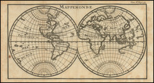
Striking double hemisphere map of the World, published in Paris in 1776.
This remarkable map, originally published by De Vaugondy in 1752 and here updated with significant revisions and updates.
The map notes the routes of the Manila Galleon Trade, as well as recent French discoveries in the Southern Atlantic. The map shows route of the 1738-9 voyage of Jean-Baptiste Charles Bouvet de Lozier (1705-86), commanding the ships Aigle and Marie, undertaken at the behest of the French East India Company. Bouvet's mandate was to find the apocryphal great southern continent. The map notes Bouvet's discovery of icebergs between two and three hundred feet high and half a league to two or three leagues in circumference. On January 1, 1739, Bouvet encountered an icy promontory, which he named Cap de la Circoncision, at 54° South, below Africa, supposedly located next to one of the openings of his polar sea, where he had recorded his many great icebergs .
Importantly, this was the first time land had been spotted beyond the 50th parallel South in the Eastern Atlantic. Bouvet, spotted Cap Circoncision, but severe fog and ice ensured that he was unable to explore the area further, and thus he was unaware that the landmass was part of an island, and not a southern continent. Bouvet lost sight of the cape and was unable to relocate it in the days that followed. For many decades after this map was printed, it remained a mystery as to the true nature of this discovery. Bouvet's plotting of his course was innacurate, and in spite of several attempts, the cape was not encountered again until 1808, when it was proven to be an island. Named Bouvet Island, it is one of the World's most isolated points of land, very distant from both Africa and Antarctica, and is today administered by Norway.
Gilles Robert de Vaugondy (1688-1766) and Didier Robert de Vaugondy (1723-1786) were influential figures in the realm of 18th-century French cartography. Originating from Paris, their contributions to mapmaking were significant during an era of expansive geographical exploration.
Gilles Robert de Vaugondy entered the world of cartography not through family tradition but through personal interest and the budding opportunities of his time. Born in 1688, he worked during a time when Paris was becoming a central hub for cartographic activities. Gilles often incorporated the latest findings from explorers into his maps, making them sought-after for their contemporary relevance. His connections weren't limited to his immediate circle; he frequently interacted with other key mapmakers, staying updated on the latest techniques and findings.
His son, Didier, was born in 1723 and had the advantage of growing up surrounded by maps and globes. While his father was renowned for maps, Didier made a name for himself in the field of globemaking. His globes were some of the most precise and detailed in France, gaining recognition even among the royalty. In addition to his work in cartography and globemaking, Didier had a keen interest in education, especially after the expulsion of the Jesuits from France. He stepped in to produce geographical educational materials, fulfilling a newfound need.
The maps and globes produced by the Vaugondys remain an enduring testament to the peak of French cartography during the Enlightenment. Their works, characterized by precision and the inclusion of contemporary findings, helped to shape our understanding of the world during a transformative period in European history.
![[Coffee, Tea, Vanilla & Spices / Pictorial Map of the World -- McCormick & Company]](https://storage.googleapis.com/raremaps/img/small/100117.jpg)
![Western Hemisphere [and] Eastern Hemisphere](https://storage.googleapis.com/raremaps/img/small/77831.jpg)
![Western Hemisphere. Eastern Hemisphere. [showin the Republic of Texas]](https://storage.googleapis.com/raremaps/img/small/82886.jpg)