


|
||

|

|
|

|
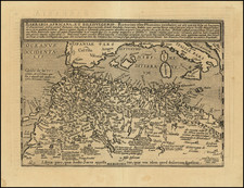
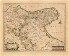
Detailed map of the Roman Empire, as described by the 1st Century Historian Lucio Anneo Floro.
DuVal bases his map on the works and maps of Lucio Annaeo Floros. Lucio Anneo Floro was a Roman historian of the first century AD. This was the time of the Roman Empire under Trajan and then Hadrian, when Rome had expanded to its fullest extent and was then in a state of peace; Pax Romana.
Floro is most noted for compiling the information from another historian, Titus Livius Patavinus and making his own brief sketch of the history of Rome from the foundation of the city to the closing of the temple of Janus by Augustus in 25 BC. Floro also preaches about the greatness of Rome in his writings, and divides the empires life into the periods of infancy, youth, and manhood.
The title of this map, Imperii Romani Iuventus, reflects Rome in its youth. The Roman Empire is shown at the beginning of the Empire and the end of the Republic.
Juventas is the Roman goddess of youth and rejuvenation, and was the goddess of young men who are coming of age. It was many peoples belief that Rome had come of age under Caesar's wars and expansions, such as on Imperial coins. Juventas and Spes (Hope) are often associated with Caesar's reign.
The map reflects the largest expanse of Roman conquests. Caesar would lead the Gallic wars and add Western Europe to the Republic, the first Roman general to invade England and pacifies the Germanics. Once the conquest was over, the Roman Senate ordered Caesar to step down from his military command and return to Rome. Caesar refused the order, and instead crossed the Rubicon River in 49 BC with a legion, leaving his province and illegally entering Roman Italy under arms. Civil war resulted.
Following his vicotry, Caesar assumed control of the government, instituting social and governmental reforms, and centralizing the bureaucracy of the Republic. He was eventually proclaimed dictator in perpetuity giving him even more authority and power, until his assasination on March 15, 44 BC.
The aftermath of this coup was three different civil wars and years of political turmoil and conflict for control of the empire. This era ended with the victory of Octavian, Caesar's adopted son. The Roman Senate then formally granted Octavian overarching power and the new title, Augustus. This marked the beginning of the Roman Empire which would last 500 years and Pax Romana which was its first two centuries.
Pierre Duval (1618-1683) was a French geographer, cartographer, and publisher who worked in Abbeville and Paris during the seventeenth century. He was born in the former city, in northeast France, before moving to Paris. Duval was the nephew of the famous cartographer Nicolas Sanson, from whom he learned the mapmaker's art and skills. Both men worked at the royal court, having followed the royal request for artists to relocate to Paris. In addition to numerous maps and atlases, Du Val's opus also includes geography texts. He held the title of geographe ordinaire du roi from 1650 and died in 1683, when his wife and daughters took over his business.
![A New Map Shewing all the several Counties, Cities, Towns, and other Places mentioned in the New Testament . . . [shows Cyprus]](https://storage.googleapis.com/raremaps/img/small/90593.jpg)