


|
||

|

|
|

|
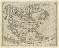
Nice example of Henry Briggs map of North America, one of the most important and influential printed maps of the 17th Century.
Briggs map includes a number of important "firsts," including:
- first English map to show California as an Island
- first map to name Cape Cod
- first map to name Delaware Bay
- first map to name Hudson Bay,
- first map to name Hudson's Strait
- first map to name Hudson River
- first map to name San Diego (along with Goos)
- first map to name Monterey (along with Goos)
The map also includes very early appearances of Plymouth and James Citti on the East Coast.
While the map post dates Goos 1624 map showing California as an island, most authorities believe that the Briggs map was the source map for the Goos. Similar errors appear on both, and the East Coast and English nomenclature are similar, particularly in New England, where only the English had explored to that date. Briggs wrote of California's insularity as early as 1622. Burden surmises that the Briggs map may have either been issued first or that the maps have a common English source. The map gives credit to Spanish sources for the insular California theory. Vizcaino's 1602 expedition to the west coast is in evidence for the first time on a printed map (along with the Goos map).
Another major breakthrough discussed by Henry Wagner is signficantly revised treatment of the Rio Grande River (also present on the Goos map). Earlier maps (pre-dating the depiction of California as an island) show a series of rivers flowing and draining the southwest, with their confluence at the head of the Gulf of California. With California's new found insularity, a single river course is shown flowing from the North, passing Santa Fe (Real de Nueva Mexico) and finding its outlet at 30 degrees latitude. This course of the Rio Grande (or Rio del Norte), would be adopted by subsequent mapmakers depicting California as an Island, and would copy this depiction of the Rio Grande until Nicolosi's map of 1660 correctly showed the Rio Grande flowing into the Gulf of Mexico.
In the Southwest, a number of other important locations are given. The Real de Nueva Mexico (Santa Fe), and Pueblos de Moqui (Moqui Villages), derive from the expeditions of Juan de Oñate, a Spanish Conquistador, explorer, and colonial governor of the Santa Fe de Nuevo México province in the Viceroyalty of New Spain. He led early Spanish expeditions to the Great Plains (1601), and Lower Colorado River Valley (1604), the latter being the only recorded European travels into the region between the expeditions of Hernando de Alarcón and Melchior Díaz in 1540, and the visits of Eusebio Francisco Kino beginning in 1701. It is also believed that Oñate is one of the sources for the myth of the island of California.
As noted in Burden,
Henry Briggs was a leading mathematician of his day . . . Engraved by Reynold Elstracke, the map contains three legends. Two of these show clear knowledge of the journals of a number of the Northwest Passage explorers. Briggs refers to the various tides found and uses them as evidence that a sea route exists to the South Sea or OCEANUS IAPONICVS. The third begins, 'California somtymes supposed to be a part of ye westerne continent, but scince by a Spanish Charte taken by ye Hollanders it is found to be a goodly Ilande. . . .' recording the Spanish origins of this theory.
Hubert Howe Bancroft notes that the location of Astablan is an erroneous spelling of Azatlan, but Rey Coromedo, Laueo de Oro and Rio Anguchi are all unexplained. Henry Wagner speculated that Anguchi was a misspelling of Anpach, word which Friar Francisco de Escobar, a member of the Oñate expedition to the Lower Colorado Valley and one of its principal chroniclers, reported meant gold, in the language of the Colorado Indians. Similarly Wagner speculates that Rey Coromedo is an erroneous spelling of Rey Coronado.
Briggs wrote A treatise of the North-West Passage, which was reprinted by Haklyut in volume 3 of Purchas' Pilgrimes, with the section illustrated by this map . The map does not clearly delineate a Northwest Passage, but certainly leaves the question open.
One of the most important map of North America published in the first part of the 17th Century.
Henry Briggs (bap. 1561-1631) was an English mathematician. He is best known for his pioneering work on logarithms and his 1625 map depicting California as an island, the first English map to do so. He hailed from Yorkshire and attended St John’s College, Cambridge, where he studied mathematics. In 1597, he was appointed as geometry professor at Gresham College, London, where he wrote several treatises on mathematics and navigation. Inspired by the work of John Napier, Briggs focused his research on the computation of logarithms. In 1619, Briggs took up the newly-created Saville Professorship of geometry at Oxford and lived in Merton College. He died there in 1631.
![Die Vereinigten Staaten von Nord Amerika (Ostlicher Theil) [New York City Inset]](https://storage.googleapis.com/raremaps/img/small/62359.jpg)

![[Winchester Bay, Oregon to Crescent City California] Pt. St. George to Umpqua River California and Oregon](https://storage.googleapis.com/raremaps/img/small/79292.jpg)