|
||

|

|
|

|
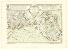
Saliba Inspired Map of the Cosmos, Integrating Pagan, Medieval Christian and Renaissance Influences.
Rare separately issued map of the cosmos, integrating ancient Pagan and medieval Christian cosmology with Renaissance beliefs and experiences.
The map is a virtually unknown derivative of Antonino Saliba's 1582 wall map model of the Cosmos, which was subsequently copied by De Jode in 1593. As noted in the description of Saliba's map in the History of Cartography, Vol 3, Plate 1:
Saliba's map is confined to the elemental spheres of the cosmos, its concentric circles expanding from a subterranean zone of metls, fires and aquifers, through a terraqueous surface illustrated by a crude polar world map, to three zones of air corresponding to Aristotle's meteorological theory and finally, to the zone of fire with its phoenix and salamander. Saliba's subsurface cosmography reveals various levesl of activity; huamn mining in addition to natural phenomena such as subterranean waters, volcanic activity, hot springs, and the spread of metallic veins believed to grow within the living body of earth. In some versions, the earth's core is represented as hell, while the sun and moon appear in the corners of the chart to suggest the planetary spaces beyond. Phenomena in the three regions of air fell withing the scope of cosmography, as Apian's revolutionary images of comets' tails pointing toward the sun indicate.
The map presents the universe as a place that is simultaneously ordered and chaotic, spiritual and temporal, familiar and fantastical. The map shows eight concentric rings, from the inner ring depicting the infernal regions to an encircling ring of fire.. The fourth ring is a hemispheric map on a south-polar projection. Within the spandrels are decorative images of the sun and moon.
The cosmic model of concentric rings was derived from Aristotle and Ptolemy, which in modified forms prevailed until the seventeenth century. The Ptolemaic model comprised nine spheres around the earth: five planets, the sun, the moon, the stars, and the primum mobile. This departure from the classical content of the nine spheres while retaining the structure, is entirely typical of the fluid state of Renaissance science. The regions (starting with the innermost ring) are:
- Centre du Globe Terrestre
- Feu Central Selon Les Philosophes
- Solidite Du Globe Terrestre
- Face Du Globe Terrestre
- 1ere ou Basse Region
- Seconde Moyene Region
- Troisime Haute Region
- Region du Feu
- Confins De La Region Celeste
The map's title suggests that this is a new edition, reviewed and corrected by Gregoire Mariette in Paris in 1696. The map was first issued by Jean Boisseau in 1638, with the title Tabble Des Meteore avec Lordre et Scituations Des Elementz . We note that the only recorded examples of the map are in the Bibliotheque Nationale de France and appear to includes two states:
- Title in Africa: Tabble Des Meteore avec Lordre et Scituations Des Elementz A Paris. Chez I Boisseau a la fontaine de Jouueuce (?) 1638. The primary difference in the two maps is that the earlier state does not include the names of the rings, except for the second name above. gallica.bnf.fr/ark:/12148/btv1b8491375m
- Re-engraved to remove title, add names to rings and add name at the top of the map.
We located very little information about Gregoire Mariette (1646-1710), other than a note that he was the brother of Pierre and likely employed in the family printing and engraving business in Paris and that his name appears on several French maps between 1694 and 1697.
In fact, both the Boisseau and Mariette editions of the map would appear to be virtually unknown to modern bibliographers and scholars.
The map is of the utmost rarity. We know of no other examples, outside the BNF.

![Globi Coelestis In Tabulas Planas Redacti Pars II . . . [Pegasus, Capricorn, Aquarius, Pisces Cetus, Aries, Andromeda, Equuleus]](https://storage.googleapis.com/raremaps/img/small/71151.jpg)
![[ Compass Rose ]](https://storage.googleapis.com/raremaps/img/small/85884.jpg)