|
||

|

|
|

|
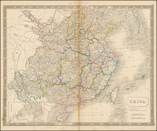
Rare early map of China, published by Theodore De Bry in his Historiarum Orientalis Indiae tomus XII, first published in 1628.
De Bry's map of China is based upon Samuel Purchas' highly important 1625 map of China, which is widely regarded as the first map of China western published map to have been derived directly from Chinese sources.
The Purchas map of China is based upon a Chinese woodblock sheet map, which had been acquired by Captain John Saris in Bantam sometime between December 1608 and October 1609. Saris, then serving as chief factor in Bantam for the East India Company, had taken it from a Fujianese merchant in partial settlement of a debt owed to Saris. Saris in turn delivered the map to Richard Haklyut, who in turn gave the map to Purchas during the time period when Purchas was translating Hugo Grotius' Mare Liberum.
Purchas included the map in his 1625 Hakluytus Pothumus or, Purchas his Pilgrimes, a collection of travel writings, based on the work of the famous geographer, Richard Hakluyt (1552-1616). Purchas refers to the map as
The Map of China, taken out of a China Map printed with China characters, etc. gotten in Bantam by Capt. John Saris.
The title transliterates as "Huang Ming yitong fang yu bei lan," meaning Comprehensive view map of the Imperial Ming. The original Saris-Haklyut-Purchas map was written entirely in Chinese. Because Purchas could not translate the map, he removed the Chinese characters from the body of the map, using symbols to depict the towns, rivers and mountains.
It is possible that this Chinese map was the 1593 "Cao Map", of which there is now only one recorded example.
Squares and circles depict cities and settlements. The provinces of China are marked and boundaries shown, for perhaps the first time on a Western map. Macau and Canton (Guangzhou) are both named. The vignettes in the corners depict Matteo Ricci and a Chinese couple.
The map is perhaps the most influential map of China published in the first half of the 17th Century. The general construction of the map is a significant improvement from Ortelius' map of China of 1584, which is drawn directly from reports of the Portuguese mapmaker Luis Jorge de Barbuda (Ludovicus Georgius), who made a manuscript map of China which reached Ortelius via Arias Montanus.
A nice example of this map of landmark importance in the history of the mapping of China.
Theodor de Bry (1528-1598) was a prominent Flemish engraver and publisher best known for his engravings of the New World. Born in Liege, de Bry hailed from the portion of Flanders then controlled by Spain. The de Brys were a family of jewelers and engravers, and young Theodor was trained in those artisanal trades.
As a Lutheran, however, his life and livelihood were threatened when the Spanish Inquisition cracked down on non-Catholics. De Bry was banished and his goods seized in 1570. He fled to Strasbourg, where he studied under the Huguenot engraver Etienne Delaune. He also traveled to Antwerp, London, and Frankfurt, where he settled with his family.
In 1590, de Bry began to publish his Les Grands Voyages, which would eventually stretch to thirty volumes released by de Bry and his two sons. The volumes contained not only important engraved images of the New World, the first many had seen of the geographic novelties, but also several important maps. He also published a collection focused on India Orientalis. Les Grands Voyages was published in German, Latin, French, and English, extending de Bry’s fame and his view of the New World.
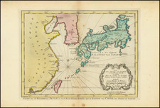
![(Eastern and Central Mongolia) VIIe. Feuille particuliere de la Tartarie Chinoise: qui contient la plus grande partie du païs occupé par les Tartares Kalkas [Map of Chinese Tartary which contains the greatest part of the country occupied by the Tartar Kalkas]](https://storage.googleapis.com/raremaps/img/small/90644.jpg)
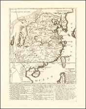
![[Shanghai, Hangzhou, Suzhou, Nanjing] Province De Kiang-Nan](https://storage.googleapis.com/raremaps/img/small/68934.jpg)