This item has been sold, but you can enter your email address to be notified if another example becomes available.


|
||

|

|
|

|
Stock# 41732
Description
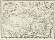
First edition of this scarce and highly detailed general map of the northwest boundary of Texas.
The map was originally prepared in 1860, but went missing for nearly 40 years, but later found original in the U.S. General Land Office. The Clark survey was executed in 1859-60, ten years after Texas sold its northern and western lands to the United States for $10,000,000.

![Carte De La Louisiane Et Du Cours Du Mississipi . . . Juin 1718 [1st State!]](https://storage.googleapis.com/raremaps/img/small/59797.jpg)