


|
||

|

|
|

|
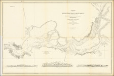
The Earliest Map of the Lower Sacramento River and San Joaquin River (Sacramento Delta)
One of the earliest obtainable privately issued California charts, tracking the lower Sacramento and San Joaquin Rivers as they leave the Gold Regions of California and flow into Vallejo and Suisun Bays, before the two bays empty into San Francisco Bay.
Fine large format navigational chart showing the waterways from Benicia to Suisun City, with soundings, hazards, and currents all noted. Benicia was founded in 1847, the first town in California founded by Anglo-Americans. A city named New York of the Pacific (present-day Pittsburg) is shown opposite Gwin Island. Three profile views of Benecia, Tongue Shoal and the entrance to Sacramento River extend along the bottom.
Cadwalader Ringgold was a US Navy officer who served in the US Exploring Expedition and later headed an expedition to the Northwest, before retiring briefly before the Civil War. Ringgold entered the US Navy in 1819 and commanded the schooner Weazel against West Indian pirates in the late 1820s. From 1838 to 1842, he participated in the Wilkes Expedition. In August 1841, Ringgold led a 60-man exploring party in San Francisco Bay, exploring the sources of the Bay for 20 days. This expedition traveled as far as Colusa, California.
In July 1849, Ringgold returned to San Francisco as commander of an official survey team surveying the harbor, shortly after the announcement of the discovery of gold in California.
Ringgold's next expedition, the North Pacific Exploring and Surveying Expedition, ended prematurely for Ringgold when he contracted Malaria. The expedition was met in China by a separate expedition under the command of Commodore Perry, who convened an official panel, which determined that Ringgold was "insane" and relieved him of his command.
Ringgold's charts from his San Francisco Bay Surveys were published in A Series of charts, with sailing directions, embracing surveys of the Farallones, entrance to the Bay of San Francisco ... State of California, beginning with the 3rd edition in 1852. The work has the distinction of being the first set of published charts focusing on California and is an essential work for California collectors.
![[Central Riverside County] Riverside Quadrangle](https://storage.googleapis.com/raremaps/img/small/83568.jpg)
![(Pacific Coast Exploration) Relacion del viage hecho por las goletas Sutil y Mexicana en el año de 1792 para reconocer el Estrecho de Fuca: con una introduccion en que se da noticia de las expediciones executadas anteriormente por los españoles en busca del paso del noroeste de la América. [Account of the voyage undertaken by the schooners Sutil and Mexicana in the year 1792 to explore the Strait of Juan de Fuca: with an introduction that provides information about the expeditions previously carried out by the Spaniards in search of the Northwest Passage of America.]](https://storage.googleapis.com/raremaps/img/small/94653.jpg)
![(Southern California) Utazás Kalifornia Déli Részeiben [Travel in Southern California] [with map:] Kalifornia déli részei Legújabb kútfök után szerkesztette es rajzolta. [Southern parts of California Edited and drawn after the latest sources.]](https://storage.googleapis.com/raremaps/img/small/92022.jpg)