|
||

|

|
|

|
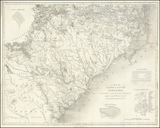
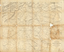
Fine example of this rare and highly detailed large format map of North Carolina, published in Raleigh, North Carolina by A. Webster Shaffer.
Shaffer's map of North Carolina is perhaps the best and largest format of the State published in this time period and the likely only large format map of the state produced in Raleigh in the 19th Century. Its detail is without peer.
Shaffer's map is the first township map of North Carolina. While townships had been established in North Carolina during Reconstruction in 1868, they were very quickly undone by the constitutional convention of 1875. The North Carolina Map Blog notes: blog.ncmaps.org/index.php/nc-townships"
A. Webster Shaffer, a New Yorker, was an officer in the U.S. Army when sent to Raleigh in 1866. He apparently liked it here. Two decades later, he was still residing in Raleigh when he published "The first Township map of North Carolina ever issued." It's quite curious that Shaffer would perceive a need for a township map in 1886. Granted, townships were a relatively new concept to North Carolina, but less than 20 years after their legislative creation by the 1868 constitution, townships were already insignificant from a political perspective. Native North Carolinians had regained control of the legislature by 1875 when another constitutional convention wrote amendments, subsequently approved by voters, that essentially abolished any governmental functions of the township. Yet 140 years later, North Carolina still has its townships, used primarily for locating tax listings and voting precincts.
Shaffer's Township Map of North Carolina was published as a 40 x 75 inch wall map at a scale of 7 miles to the inch, and as a slightly smaller pocket map at a scale of 10 miles to the inch. . . . Although most counties named their townships, a few (e.g. Forsyth County) originally just numbered them.
Was Shaffer's map truly the first township map of North Carolina, as he claimed? We may have to get a legal ruling, but I'd be inclined to agree with him. Eleven years earlier, George Cram published Cram's Rail Road & Township Map of North and South Carolina, but one might spend an eternity trying to find any townships on the map . . .
Little is known about Shaffer, who also produced maps of the City of Raleigh, N.C. (1888); Wake County, N.C. (1886 and 1887).
At the top left corner, a text section titled "The Cherokee Indians" describes the history of the treaties with the United States, as follows:
By the terms of the Treaty of 1785, this tribe was taken "under the protection of the United States of America," and "to them and their nation forever" was allotted in common an imperial domain, carved out of Georgia, Alabama, Tennessee and North Carolina. Thirteen subsequent treaties, covering a period of thirty-four years, sufficed to transfer this vast territory from the Ward to the Guardian, with boundaries so vague and obscure as to baffle all attempts to trace them.
Whether by obscurity originated in profound ignorance or in very expert diplomacy, would remain an indeterminate problem but for an incident attending the execution of the fourteenth Treaty, by which the United States acquired the last remnant of their lands, and the chiefs subscribed deportation of the Nation to the Wilds of the Great West.
Thirty-one families refused to be bound by the Treaty; fled to the woods, and remained concealed until the removal of the remainder was accomplished. The Treaty of 1819, the last of the series, followed, whereby the United States allotted in severalty to these thirty-one families the sum of 12,697,600 acres of land; that is to say, six hundred and forty square miles each, or in the language of the treaty, -- "six hundred and forty acres square each!" -- a territory equal to more than one-fourth of North Carolina! An unconscious saving clause provided that each allotment should be centered upon the improvement of each family respectively, whereby they should be laid out one atop of another, like the great stones of Cheops.
Perhaps the most comprehensive, if not the most exact, description of the resultant locus in quo may be found in the letter of a young Cherokee student, which appeared in The Family Visitory, of Richmond, VA, September 2, 1825, six years after the conclusion of the last treaty, to with:
"The Cherokee Nation is bounded on the north and west by the State of Tennessee, on the south by Alabama, and on the east by Georgia and North Carolina.
The author attempted to digest the various treaties as to show upon this map the boundaries of the "Cherokee Nation," but was confronted and confounded by a mathematical scholium familiar to every modern school-boy, to with "A POINT has neither parts nor magnitude," and thereupon he lettered The Reservation, and left the boundaries to the determination of the surveyors, to enclose 640 acres each, or 409,600 acres each, as they may be influenced by the manifest intent, or the plain letter of the Treaty.
Also includes a large profile inset illustrating the heights of the mountains in the Alleghany Range and the Blu Ridge Range.
Shaffer's map is exceedingly rare on the market. We note only the example sold by Dorothy Sloan (Oct 26, 2007, Lot #126). OCLC locates examples at Duke, High Point Public Library, University of North Carolina at Greensboro and Chapel Hill, State Library of Massachusetts and the Abraham Lincoln Public Library.
Provenance: Charlton Hall, April 2015: Formerly from the Columbus Museum, Columbus, Georgia.

![County Map of Florida [with Maps of North & South Carolina and inset of Charleston]](https://storage.googleapis.com/raremaps/img/small/92536.jpg)
![Gray's New Map of North Carolina and South Carolina [Charleston Harbor Inset]](https://storage.googleapis.com/raremaps/img/small/98362.jpg)