|
||

|

|
|

|
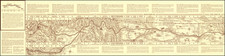
Unrecorded birdseye view style map of the Keyston Mining District, showing the gold fields of La Belle, New Mexico, lithographed by the Pueblo Lith Co. and published by C.H. Amerine of Colorado Springs, Colorado in 1895.
Located in the Sangre de Christo Mountains, about 30 miles north of Taos, New Mexico, in Taos County, the view illustrates a mining boom region which quickly busted and is now virtually untraceable in modern times.
The map is oriented with east at the top and meticulously illustrates the region, incluiding 3 boom towns, over 100 mines, saw mills, creeks, trees and ranges. Lower left corner has an inset of La Belle area, towns and railroads. Lower right corner has an inset that depicts a miner at a campfire and his pack mule.
Towns named include Midnight City, Anchor and La Belle, the latter of which was served by the Catskill and La Belle Stage Line and a Telelphone Line! Van Diest Mountain, Bitter Creek and Camanchee Creek are shown, as is Costilla Peak at the top right corner.
In 1894, gold was discovered by Ira Wing along Comanche Creek in today's Valle Vidal section of the Carson National Forest. At the time the area was part of the Costilla Estate of the Sangre de Cristo Land Grant and was owned by a Dutch company, operating as the U. S. Freehold Land and Emigration Co. Within a year of the discovery, hundreds of miners and prospectors flooded the valley and as a result, the town of La Belle came into being. Mining claims were staked over a wide area and mines were opened, necessitating the formation of the Keystone Mining District.
Since this district was located on private property ( the Freehold Land and Emigration Co.), there were extra fees and costs for establishing a mining claim. As a result, a number of prospectors travelled westward a few miles, crossed a ridge, and came down into Bitter Creek. This was located on U. S. government land which was open to homesteading and here the claims filing costs were significantly less. Near the headwaters of Bitter Creek a number of cabins were built, several mines were opened and the town of Anchor was established in 1895.
La Belle was a mining town eight miles northeast of Red River which had a post office from 1895-1901. As a gold mining camp, it was named after Belle Dixon in 1894, who was the wife of one of the original investors in the mining area. Within one year there were eighty buildings and six-hundred residents, including twelve women - wives of miners.
The production was somewhat uneven, varying from thirty to a thousand dollars of gold per ton of ore. Because of the continued presence of the richer ore, the owners became optimistic and in 1898 decided to order a ten-stamp mill from Denver. While awaiting shipment of the equipment, the mill site was prepared and all the necessary construction was completed. The following year the mill began actual work under the direction of superintendent L. E. Pennock. Initial results were encouraging but over time the quality of the ore became less, so that the value of the mill production barely covered expenses. This was aggravated by the fact that the mine tunnel was located only slightly above the level of the creek and thus, water in the mine was an ongoing problem. As a result of all the difficulties, the mill and mine work was gradually cut back and finally the mine was shut down.
In 1910 there was a general revival of gold mining in the Red River area, brought about by some new discoveries, improved economic conditions throughout the region, and better methods of extracting the gold. A number of mines were reopened. However, the mill production was once again disappointing and only managed to cover expenses.
La Belle is also the name of the gold and silver mining district.
On the verso, there are sketches of mining claims.
The view is unrecorded, with no copies in Reps or OCLC. This is the only surviving example of which we are aware.