|
||

|

|
|

|
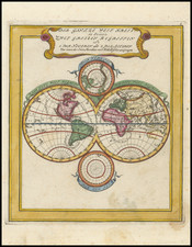
Finely engraved map of the World, surmounted by 4 smaller hemispheric projections, illustrating the routes of major explorers.
The map depicts California as an Island, the Mississippi River pushed far to the west of its true terminus in the Gulf of Mexico, and a massive land bridge (Terra Esonis) extending from California to Japan.
The coastline of Australia is beginning to take shape, although little is known about the southern and eastern coastlines. Van Diemen's Land (Tasmania) is well outlined, as is one coastline of New Zealand, as discovered by Abel Tasman.
Korea is a narrow peninsula, with a massive Philippines dominating the region to the west of China and the Malay Peninsula.
The Northeast Passage is clearly shown, but no polar passage above North America is evident.
The map includes two smaller polar hemispheric projections, along with a model of the Solar System, based upon Ptolemy, an eclipse model, etc.
![World [Rand, McNally & Company's Indexed Atlas of the World]](https://storage.googleapis.com/raremaps/img/small/100314.jpg)