|
||

|

|
|

|
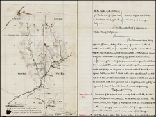
Historically significant early map of San Francisco and the northern Peninsula, with Original Report.
The Map of the Northern Portion of San Francisco County is one of the most important of the great early maps of San Francisco and environs. Published in 1852 to accompany the Manual of the Corporation of the City of San Francisco, it is one of the first maps of San Francisco published in San Francisco and a map of primary importance for its early depiction of what would become San Francisco County.
Also included in this rare work is B.F. Butler's Map of San Francisco. Butler' created what is generally regarded as the first map of San Francisco published in San Francisco, in 1851. This is his second map and extremely rare on the market.
In 1852, the City of San Francisco occupied only the northeastern portion of the current city and county of the same name. The city was also part of the County of San Francisco, which was separately governed and included the area occupied by today's San Francisco as well as most of modern San Mateo County. However, San Francisco's Board of Supervisors harbored ambitions to expand the city beyond its modest limits. As the mapping of the city had hitherto generally been tightly confined to the densely settled area in what is now downtown San Francisco, they decided to commission a map that showed the territory which ran west and south of the city.
Overall responsibility for the map fell to Clement C. Humphreys, the Surveyor of the County of San Francisco. Humphreys compiled the very best available surveys and tendered them to Alexander Zakreski, a master cartographer and draughtsman, whose biography is one of the most fascinating of all early San Franciscans.
Alexander Zakreski (1799-1866), born Aleksander Zakrzewski, was a brilliant Polish military engineer and revolutionary who had to flee his native land owing to his opposition to Russian rule. He then settled in France where he lithographed a map of Paris in 1839. He was subsequently caught up in the Revolution of 1848 and had to leave the county, finally arriving in San Francisco in 1850. Zakreski soon found work as a mapmaker and lithographer, working with various governmental agencies, as well as commercial publishers. In 1852, he worked closely with the County Surveyor's Office. He is perhaps best known for bing the author of The only correct & fully complete Map of San Francisco (1854).
Once the manuscript draft of the map had been completed, the Board of Supervisors issued their Joint Resolution no.282, dated December 24, 1852:
"Authorizing the Reviser of the City Ordinances, etc., to have a map lithographed…The Said map being a map of the northern portion of San Francisco County, Compiled in the county Surveyor's Office, June 1, 1852, by Clement C. Humphreys, County Surveyor, and copied by Alexander Zaresky [sic]."
The map was printed map the firm of B.F. Butler, and included within a book issued by the Supervisors, detailing the city's laws and regulations, the Manual of the Corporation of the City of San Francisco (dated 1852, but issued 1853).
The map embraces all of the San Francisco Peninsula from San Bruno northwards. It labels all of the ranchos (including their acreages), major regional roads, as well as the Presidio and the Telegraph Station above Fort Point. The vast barren area to the southwest of the Golden Gate is labeled the 'Great Sand Bank'. While the city limits of San Francisco are demarcated (including the boundary extensions of 1850 and 1851), the only man-made detail within the city itself is the 'Line of Market Street' and the 'Mission' (Mission Dolores), owing to the fact that this was primarily intended to be a regional map. Relief is expressed through finely engraved hachures and marshlands are carefully distinguished.
The Map of the Northern Portion of San Francisco County is one of the great rarities amongst important early works of San Francisciana. We are aware of it appearing only once at auction in the last 25 years and are not aware of it appearing in any dealer's catalogs over the same period. Moreover, the last recorded sale of the Manual of the Corporation of the City of San Francisco, complete with its 2 maps, occurred in 1979 (Warren Howell).
An essential work for San Francisco Collectors.
![[Limited Edition of 33] The Sculpture & Art of Jo Mora](https://storage.googleapis.com/raremaps/img/small/94900.jpg)