|
||

|

|
|

|
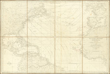
Detailed map of St. Lucia, illustrating the naval battle between the French and English Naval forces on the west side of St. Lucia in 1778.
The map shows the French land forces and the naval forces of the French and English in this important Caribbean Battle, which resulted the English defeat of the French and seizure of the French Garrison at St. Lucia on December 28, 1778.
On September 7, 1778, the French governor of Martinique, the marquis de Bouillé, surprised and captured the British island of Dominica. On November 4, 1778, French Admiral Jean Baptiste Charles Henri Hector. comte d'Estaing sailed for the West Indies from the port of Boston. On that same day, Commodore William Hotham was dispatched from Sandy Hook, New York, to reinforce the British fleet in the West Indies. The convoy Hotham was escorting consisted of 59 transports carrying 5,000 British soldiers under Major General Grant.
The French fleet was blown off course by a violent storm, preventing it from arriving in the Caribbean ahead of the British. Admiral Samuel Barrington, the British naval commander stationed on the Leeward Islands, joined the newly arrived Commodore Hotham on December 10, 1778, at the island of Barbados. Grant's men were not permitted to disembark and spent the next several days aboard their transports. Barrington and Hotham sailed for the island of St. Lucia on the morning of December 12.
On December 13 and 14, Major General James Grant, supported by additional troops under Brigadier General William Medows and Brigadier General Robert Prescott, landed at Grand Cul de Sac, St. Lucia. Grant and Prescott took control of the high ground around the bay, while Medows continued on and took Vigie the following morning (14 December). On 14 December the French fleet under d'Estaing arrived, forcing Admiral Barrington to move his ships into line of battle and forgo his plan of moving the transports into Carénage Bay.
Admiral Barrington in a defensive strategy placed his transports inside the bay but behind his battle line which took him the entire evening of December 14. By the next day morning, most of the transports had been safely tucked behind his line.
In the morning of December 15, Admiral d'Estaing approached St. Lucia with ten ships of the line, and was fired on by one of the shore batteries. D'Estaing then moved to engage Barrington from the rear, and a "warm conflict" raged between the two fleets, with the British supported by two shore batteries. D'Estaing was repulsed but succeeded in reforming his line of battle. In the late afternoon, d'Estaing renewed his assault by attacking Barrington's centre with twelve ships of the line. Again, heavy fire was exchanged and the French were eventually repulsed for a second time.
On December 16, Admiral d'Estaing appeared to be preparing for a third assault against Admiral Barrington's line, but then sailed away towards the windward. On the evening of December 16, d'Estaing anchored in Gros Islet Bay with "ten frigates and twelve sail of the line, &c." Admiral d'Estaing's failure to break Barrington's line on December 15 spelled doom for the local French garrison, which surrendered on December 28, 1778.
The Gentleman’s Magazine was a British publication that helped to normalize the use of maps in support of articles and features. It was founded in 1731 by the prominent London publisher Edward Cave, a pioneer in periodical journalism. The magazine continued in print for nearly two centuries, shuttering production in 1922.
This was the publication which first used the word “magazine”, from the French for storehouse. Cave wanted to create a storehouse of knowledge and he employed some of London’s best writers to fill his pages: Samuel Johnson gained his first regular employment by writing for the Gentleman’s Magazine. Other famous contributors included Jonathan Swift.
The publication covered a broad range of topics, from literature to politics, and, from 1739, frequently used maps as illustrations. The first map they printed was a woodcut of Crimea; the second was a fold-out map of Ukraine by Emanuel Bowen. Maps were used to show battle lines, to chronicle voyages, and to educate about areas with which Britain traded. Certain geographers, like Thomas Jefferys, contributed several maps to the publication.
![Culiacanae, Americae Regionis, Descriptio [with] Hispaniolae, Cubae, Aliarumqe Insualrum Circumiacientium Delineatio](https://storage.googleapis.com/raremaps/img/small/86114.jpg)
![[ Charleston, Boston, New York, St. Augustine, Bahamas, etc ] Particular Draughts of some of the Principal Towns and Harbours belonging to the English French and Spanish in America and the West Indies.](https://storage.googleapis.com/raremaps/img/small/102804.jpg)
![The Island of Cuba [with] Hayti or Santo Domingo and Porto Rico [with] The Leeward or North Caribee Islands](https://storage.googleapis.com/raremaps/img/small/78673.jpg)
![[ Virigin Islands to Trinidad and Tobago ] A Chart of the Antilles, or, Charibbee or, Caribs Islands, with the Virgin Isles . . . MDCCLXXXIV](https://storage.googleapis.com/raremaps/img/small/103660.jpg)