|
||

|

|
|

|
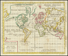
One of the earliest appearances of the Sea of the West on a printed map, following J.N. De L'Isle's monumental map of 1752.
Prepared by the Royal Geographer, Jean Beaurain, the map depicts many of the most important discoveries of the prior decade, including most notably the Russian discoveries reported by De L'Isle in the north Pacific.
Of perhaps equal note is the extraordinary depiction of the discoveries of Bouvet in 1738-39. In 1738-9, the voyage of Jean-Baptiste Charles Bouvet de Lozier (1705-86), commanding the ships Aigle and Marie, was undertaken at the behest of the French East India Company. Bouvet's mandate was to find the apocryphal great southern continent. The map greatly over-dramatizes Bouvet's discovery of icebergs between two and three hundred feet high and half a league to two or three leagues in circumference. On January 1, 1739, Bouvet reportedly encountered an icy promontory, which he named Cap de la Circoncision, at 54° South, below Africa, supposedly located next to one of the openings of his polar sea, where he had recorded his many great icebergs .
Importantly, this was the first time land had been spotted beyond the 50th parallel South in the Eastern Atlantic. Bouvet, spotted Cape Circoncision, but severe fog and ice ensured that he was unable to explore the area further, and thus he was unaware that the landmass was part of an island, and not a southern continent. Bouvet lost sight of the cape and was unable to relocate it in the days that followed. For many decades, it remained a mystery as to the true nature of this discovery. Bouvet's plotting of his course was inaccurate, and in spite of several attempts, the cape was not encountered again until 1808, when it was proven to be an island. Named Bouvet Island, it is one of the World's most isolated points of land.
![Carte de L'Amerique Nouvellement dressee suivant les Nouvelles descouvertes . . . 1661 [and] Carte Nouvelle de L'Europe Asie & Afrique Nouvellement . . .](https://storage.googleapis.com/raremaps/img/small/74198.jpg)
![[ World Atlas ] Geography Anatomized: or, A Compleat Geographical Grammer. Being a Short and Exact Analysis of the whole Body of Modern Geography... To which is subjoin'd the present State of the European Plantations in the East and West Indies, with a Reasonable Proposal for the Propagation of the Blessed Gospel in all Pagan Countries.](https://storage.googleapis.com/raremaps/img/small/85550.jpg)