This item has been sold, but you can enter your email address to be notified if another example becomes available.


|
||

|

|
|

|
Stock# 41183
Description
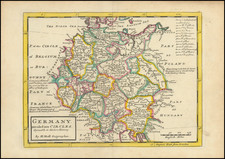
Early map showing the recently formed Kingdom of Bavaria, two years after its creation in 1805
The map is centered on Munich. Freising and Landshut and shows the Kingdom and neighboring regions.
The Kingdom of Bavaria was a German state that existed from 1805 to 1918. The Bavarian Elector Maximilian IV Joseph of the House of Wittelsbach became the first King of Bavaria in 1805 as Maximilian I Joseph. The monarchy would remain held by the Wittelsbachs until the kingdom's dissolution in 1918.
Most of Bavaria's modern-day borders were established after 1814 with the Treaty of Paris, in which Bavaria ceded Tyrol and Vorarlberg to the Austrian Empire while receiving Aschaffenburg and parts of Hesse-Darmstadt.
![Pomeraniae, Wandalicae Regionis Typ [with] Livoniae Nova Descriptio [with] Ducatus Oswieczensis, et Zatoriensis, Descriptio](https://storage.googleapis.com/raremaps/img/small/61683.jpg)