|
||

|

|
|

|
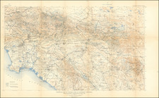
Fine example of George Wheeler's manuscript map of the Presidio of San Francisco, originally drawn by Wheeler in 1870 in connection with the establishment of the boundary lines of the San Francisco Presidio. This example being drawn by H. Von Bayer, C.E. in 1887, L.S.S. (Life Saving Service).
The presidio was originally established in 1852 by a reservation from the pueblo patent which established the legal definition of the City of San Francisco. As noted by the California Supreme Court in Wheeler v. Benjamin, 136 Cal. 51, at page 52
In the pueblo patent the exterior boundaries of the four leagues of land conveyed are fully described by courses and distances as they had been surveyed in the field. By the terms of the patent some fifteen tracts within these exterior boundaries are excepted from its operation and are not conveyed; among these tracts is the "Presidio Military Reservation." The exterior boundaries of said reservation are not given in terms by course and distance, but there is attached to and made part of the patent a map whereon the eastern boundary of said Presidio reservation is indicated as the western line of Lyon Street. It is contended by respondent that this plat, being a part of the patent, must govern as to the boundary between the reservation and the pueblo lands, and that the land east of that line was conveyed to the city by the patent.
The map was originally drawn by Wheeler in 1870, in connection with the fight over parts of the Presidio, which were in dispute in the last 1860s and early 1870s. The dispute was resolved by Congress, by the Act of May 9, 1876, entitled An act to relinquish the interests of the United States in certain lands to the city and county of San Francisco in the state of California." The present example of Wheeler's map is an 1887 copy, with minor updates and revisions, but may be the earliest surviving example of the original Wheeler manuscript map.
By 1870, disputes had arisen between the civil authorities and the Army as to the true boundaries of the Presidio of San Francisco reservation. In the spring of 1867 Deputy Surveyor James T. Stratton surveyed the "Pueblo of San Francisco" and the Presidio to establish officially the line of ownership between the federal government and the city. The city then proceeded to dispose of the lands outside the lines. Not until Brig. Gen. E.O.C. Ord took command of the Department of California in 1868 did the Army begin to question the Stratton survey. In October 1868, the Department ordered the Presidio to locate the cannon at the southeast corner of the reserve, now regarded as the initial point, that Captain Keyes had planted in 1850. The results of that dig are unknown but General Ord directed Lt. George M. Wheeler to carry out a new survey of the reservation.
Under orders from Gen. E.O.C. Ord, during his time in San Francisco, between his surveying expeditions of 1869 and 1871, Wheeler conducted 2 surveys. Wheeler mapped and surveyed the Presidio in 1868 and again in 1870 to help resolve the issue of land disputed by both the Army and the City of San Francisco. General Ord, considering the results of the Stratton and Wheeler surveys, filed a protest in November 1868. This protest showed the boundary changes that the Army insisted upon. Most prominent of these included the Army's insistence that the marsh and tidal lands along the bay in the lower Presidio be included in the reserve - the Stratton survey hadexcluded them, and a new true boundary line along the southern boundary from the initial point to Mountain Lake. This latter included a long sliver of land previously outside the boundary due to faulty surveying in the past and resulted in the Army relinquishing its claim to a triangle of land on on Lyon Street.
The City of San Francisco promptly protested Ord's claims insofar as the "tide marsh" lands were concerned. At the same time several individuals, including Adolph Hermann, claimed ownership of lands in the triangle on the east side of the reserve between future Lyon Street and Broderick Street. The Division engineer, Maj. Henry M. Robert, reported in 1870 that the Tide Land Commissioners of California claimed all the land between the shore line a nd the curves of twenty-four feet of water, and that the North San Francisco Homestead and Rail Road Association claimed ownership of the marsh land having acquired title through an act of the California legislature.
The Surveyor General's recommendations went to the General Land Office, Washington, D.C., in December 1869, where they were misplaced or lost until 1877. Meanwhile, Wheeler carried out a new survey, which resulted in the excellent 1870 maps of the Presidio. The Daily Alta California fumed, "the Commander of the Military Department, misunderstanding entirely his rights and the rights of citizens, took possession of this land, and it has been so held ever since. We are convinced that Stratton's survey was correct."
As noted by the California Supreme Court, the 1876 Act of Congress ultimately defined the Eastern Boundary as follows:
. . . Lyon Street shall be extended to the bay of San Francisco eighty feet wide, and is hereby dedicated for a public highway and street forever." It also made the grant to the city and county "for the benefit of persons, who, if the said land had not been reserved for public use, would have been entitled thereto under the ordinance numbered eight hundred of the city of San Francisco, ratified by the act of the legislature of said state, approved on the twenty-seventh day of March, 1868." (Stats. 1867-1868, p. 379.)
This edition of the Wheeler map includes several annotations dated 1887. These include the site of a Surfboat Station for the Life Saving Service and the Site L.B. Stn. Nov. 3 1887. The map likely related to the plans to improve these sites, as noted, and bears the counterstamps of the Engineers Department and the War Department on the verso, each dated 1888 and including various accession annotations in red ink.
"H. von Bayer, C.E. 1887" is almost certainly Hector Raimund von Bayer, who at different times held the positions of engineer of the Lighthouse Service and of the Life Saving Service, United States Treasury Department and civil engineer under the United States Navy Department in 1870. He also served as president of the German-American Technical Society and a member of the Cosmos Club and the Engineers' Club of Washington, D. C.
The United States Life-Saving Service was a United States government agency that grew out of private and local humanitarian efforts to save the lives of shipwrecked mariners and passengers. It began in 1848 and ultimately merged with the Revenue Cutter Service to form the United States Coast Guard in 1915.
![[Santa Cruz & Santa Clara Counties] Denny's Pocket Map of Santa Cruz County, California. Compiled From the Latest and Official Data . . . `1916](https://storage.googleapis.com/raremaps/img/small/80637.jpg)