This item has been sold, but you can enter your email address to be notified if another example becomes available.


|
||

|

|
|

|
Stock# 41090
Description
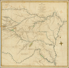
Highly detailed map of a portion of Texas, from Captain Marcy's report.
Capt. Marcy explored this region in north central Texas to locate lands suitable for the settlement of nomadic Indians. The map shows the route followed by Capt. Marcy and troops in an effort to locate land for an Indian reservation in N.W. Texas.
Map has elegant tilting with flourishes and a large fleur-de-lys; more embellishment than normally seen on U.S. government maps. Locates copper and iron ore and shows western and southern boundaries of Peter's Colony.
Condition Description
Minor tape repair to the left of the title--likely not archival tape.
Reference
Wheat Transmissippi West, #278.